You are here: Home > Network List > UW - Pacific Northwest Regional Seismic Network Stations List
> Station LEBA Lebam, WA, USA > Earthquake Result Viewer
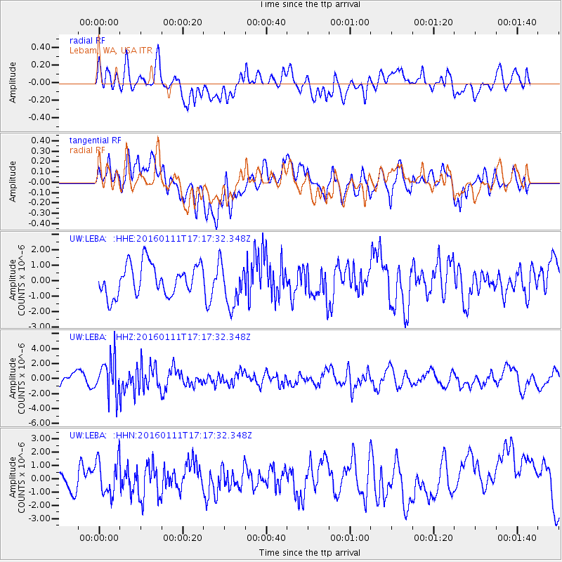
LEBA Lebam, WA, USA - Earthquake Result Viewer
*The percent match for this event was below the threshold and hence no stack was calculated.
| Earthquake location: |
Hokkaido, Japan Region |
| Earthquake latitude/longitude: |
44.5/141.1 |
| Earthquake time(UTC): |
2016/01/11 (011) 17:08:03 GMT |
| Earthquake Depth: |
240 km |
| Earthquake Magnitude: |
6.2 MWW |
| Earthquake Catalog/Contributor: |
NEIC PDE/NEIC COMCAT |
|
| Network: |
UW Pacific Northwest Regional Seismic Network |
| Station: |
LEBA Lebam, WA, USA |
| Lat/Lon: |
46.55 N/123.56 W |
| Elevation: |
73 m |
|
| Distance: |
62.7 deg |
| Az: |
50.666 deg |
| Baz: |
306.64 deg |
| Ray Param: |
$rayparam |
*The percent match for this event was below the threshold and hence was not used in the summary stack. |
|
| Radial Match: |
47.913216 % |
| Radial Bump: |
400 |
| Transverse Match: |
49.602093 % |
| Transverse Bump: |
400 |
| SOD ConfigId: |
7422571 |
| Insert Time: |
2019-04-21 17:32:06.101 +0000 |
| GWidth: |
2.5 |
| Max Bumps: |
400 |
| Tol: |
0.001 |
|
Signal To Noise
| Channel | StoN | STA | LTA |
| UW:LEBA: :HHZ:20160111T17:17:32.348Z | 3.3245454 | 2.3973698E-6 | 7.211121E-7 |
| UW:LEBA: :HHN:20160111T17:17:32.348Z | 1.397223 | 1.4181467E-6 | 1.0149752E-6 |
| UW:LEBA: :HHE:20160111T17:17:32.348Z | 1.3649848 | 1.3672986E-6 | 1.0016952E-6 |
| Arrivals |
| Ps | |
| PpPs | |
| PsPs/PpSs | |


