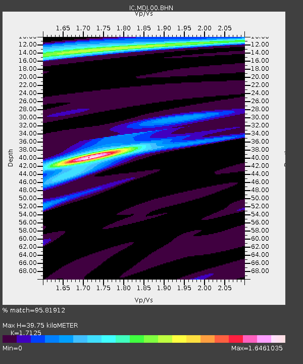
MDJ Mudanjiang, Heilongjiang Province, China - Earthquake Result Viewer

Earthquake location: Andreanof Islands, Aleutian Is.
Earthquake latitude/longitude: 51.9/-177.5
Earthquake time(UTC): 2008/05/02 (123) 01:33:37 GMT
Earthquake Depth: 14 km
Earthquake Magnitude: 6.3 MB, 6.8 MS, 6.6 MW, 6.6 MW
Earthquake Catalog/Contributor: WHDF/NEIC
Network: IC New China Digital Seismograph Network
Station: MDJ Mudanjiang, Heilongjiang Province, China
Lat/Lon: 44.62 N/129.59 E
Elevation: 250 m
Distance: 35.3 deg
Az: 279.561 deg
Baz: 58.893 deg
Ray Param: 0.0773
Estimated Moho Depth: 39.75 km
Estimated Crust Vp/Vs: 1.71
Assumed Crust Vp: 6.459 km/s
Estimated Crust Vs: 3.772 km/s
Estimated Crust Poisson's Ratio: 0.24
Radial Match: 95.81912 %
Radial Bump: 397
Transverse Match: 62.8305 %
Transverse Bump: 400
SOD ConfigId: 2504
Insert Time: 2010-03-04 23:09:17.847 +0000
GWidth: 2.5
Max Bumps: 400
Tol: 0.001

Signal To Noise

ChannelStoNSTALTA
IC:MDJ:00:BHN:20080502T01:40:00.698008Z32.049872.3873763E-67.448942E-8
IC:MDJ:00:BHE:20080502T01:40:00.698008Z19.696428.8888845E-74.5129443E-8
IC:MDJ:00:BHZ:20080502T01:40:00.698008Z24.225711.2597385E-65.2000065E-8
Arrivals
Ps4.7 SECOND
PpPs15 SECOND
PsPs/PpSs20 SECOND