You are here: Home > Network List > AU - Australian Seismological Centre Stations List
> Station XMIS Christmas Island Grants Well > Earthquake Result Viewer
XMIS Christmas Island Grants Well - Earthquake Result Viewer
| Earthquake location: |
Southwest Indian Ridge |
| Earthquake latitude/longitude: |
-31.3/58.1 |
| Earthquake time(UTC): |
2016/01/12 (012) 09:45:11 GMT |
| Earthquake Depth: |
10 km |
| Earthquake Magnitude: |
5.9 MB |
| Earthquake Catalog/Contributor: |
NEIC PDE/NEIC COMCAT |
|
| Network: |
AU Australian Seismological Centre |
| Station: |
XMIS Christmas Island Grants Well |
| Lat/Lon: |
10.48 S/105.65 E |
| Elevation: |
210 m |
|
| Distance: |
48.5 deg |
| Az: |
75.441 deg |
| Baz: |
237.42 deg |
| Ray Param: |
0.069295436 |
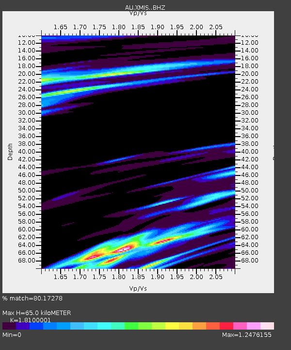
| Estimated Moho Depth: |
65.0 km |
| Estimated Crust Vp/Vs: |
1.81 |
| Assumed Crust Vp: |
4.157 km/s |
| Estimated Crust Vs: |
2.297 km/s |
| Estimated Crust Poisson's Ratio: |
0.28 |
|
| Radial Match: |
80.17278 % |
| Radial Bump: |
400 |
| Transverse Match: |
62.833244 % |
| Transverse Bump: |
400 |
| SOD ConfigId: |
7422571 |
| Insert Time: |
2019-04-21 17:34:47.272 +0000 |
| GWidth: |
2.5 |
| Max Bumps: |
400 |
| Tol: |
0.001 |
|

Signal To Noise
| Channel | StoN | STA | LTA |
| AU:XMIS: :BHZ:20160112T09:53:23.41899Z | 8.1614065 | 1.831177E-6 | 2.2437027E-7 |
| AU:XMIS: :BHN:20160112T09:53:23.41899Z | 0.8053321 | 2.7519144E-7 | 3.4171174E-7 |
| AU:XMIS: :BHE:20160112T09:53:23.41899Z | 1.9875374 | 5.265008E-7 | 2.6490108E-7 |
| Arrivals |
| Ps | 13 SECOND |
| PpPs | 43 SECOND |
| PsPs/PpSs | 56 SECOND |


