You are here: Home > Network List > IC - New China Digital Seismograph Network Stations List
> Station MDJ Mudanjiang, Heilongjiang Province, China > Earthquake Result Viewer
MDJ Mudanjiang, Heilongjiang Province, China - Earthquake Result Viewer

| Earthquake location: |
Xizang |
| Earthquake latitude/longitude: |
30.9/83.5 |
| Earthquake time(UTC): |
2008/08/25 (238) 13:21:58 GMT |
| Earthquake Depth: |
12 km |
| Earthquake Magnitude: |
6.2 MB, 6.5 MS, 6.7 MW, 6.7 MW |
| Earthquake Catalog/Contributor: |
WHDF/NEIC |
|
| Network: |
IC New China Digital Seismograph Network |
| Station: |
MDJ Mudanjiang, Heilongjiang Province, China |
| Lat/Lon: |
44.62 N/129.59 E |
| Elevation: |
250 m |
|
| Distance: |
38.4 deg |
| Az: |
55.883 deg |
| Baz: |
265.157 deg |
| Ray Param: |
0.075572744 |
| Estimated Moho Depth: |
34.0 km |
| Estimated Crust Vp/Vs: |
1.82 |
| Assumed Crust Vp: |
6.459 km/s |
| Estimated Crust Vs: |
3.559 km/s |
| Estimated Crust Poisson's Ratio: |
0.28 |
|
| Radial Match: |
96.06517 % |
| Radial Bump: |
241 |
| Transverse Match: |
83.52679 % |
| Transverse Bump: |
400 |
| SOD ConfigId: |
2504 |
| Insert Time: |
2010-03-04 23:10:15.468 +0000 |
| GWidth: |
2.5 |
| Max Bumps: |
400 |
| Tol: |
0.001 |
|
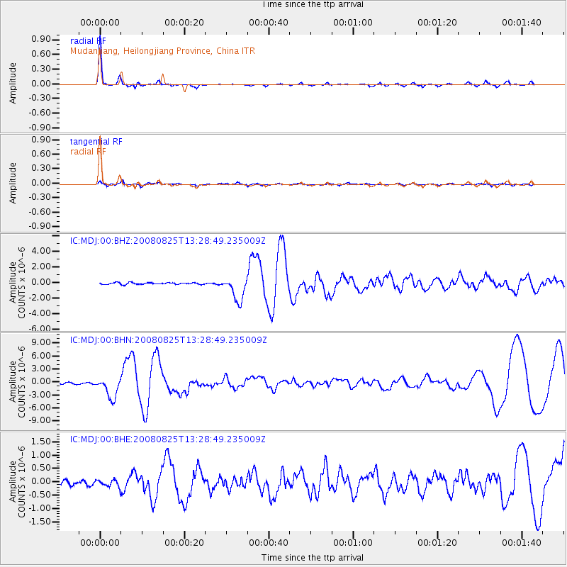
Signal To Noise
| Channel | StoN | STA | LTA |
| IC:MDJ:00:BHN:20080825T13:28:49.235009Z | 12.715881 | 2.4575952E-6 | 1.9326977E-7 |
| IC:MDJ:00:BHE:20080825T13:28:49.235009Z | 0.95771486 | 1.3521415E-7 | 1.4118415E-7 |
| IC:MDJ:00:BHZ:20080825T13:28:49.235009Z | 14.88865 | 1.5768173E-6 | 1.0590735E-7 |
| Arrivals |
| Ps | 4.6 SECOND |
| PpPs | 14 SECOND |
| PsPs/PpSs | 18 SECOND |


