You are here: Home > Network List > GS - US Geological Survey Networks Stations List
> Station OK031 2598 S. Brethren Rd., Cushing, OK, USA > Earthquake Result Viewer
OK031 2598 S. Brethren Rd., Cushing, OK, USA - Earthquake Result Viewer
| Earthquake location: |
South Of Fiji Islands |
| Earthquake latitude/longitude: |
-24.6/-176.2 |
| Earthquake time(UTC): |
2015/06/13 (164) 03:17:24 GMT |
| Earthquake Depth: |
22 km |
| Earthquake Magnitude: |
5.5 MWW, 5.5 MWB, 5.6 MWC |
| Earthquake Catalog/Contributor: |
NEIC PDE/NEIC COMCAT |
|
| Network: |
GS US Geological Survey Networks |
| Station: |
OK031 2598 S. Brethren Rd., Cushing, OK, USA |
| Lat/Lon: |
35.95 N/96.84 W |
| Elevation: |
290 m |
|
| Distance: |
96.0 deg |
| Az: |
53.303 deg |
| Baz: |
244.11 deg |
| Ray Param: |
0.040615506 |
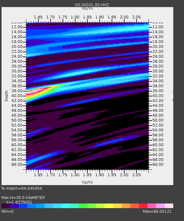
| Estimated Moho Depth: |
38.0 km |
| Estimated Crust Vp/Vs: |
1.62 |
| Assumed Crust Vp: |
6.426 km/s |
| Estimated Crust Vs: |
3.961 km/s |
| Estimated Crust Poisson's Ratio: |
0.19 |
|
| Radial Match: |
84.840454 % |
| Radial Bump: |
248 |
| Transverse Match: |
85.29918 % |
| Transverse Bump: |
340 |
| SOD ConfigId: |
976571 |
| Insert Time: |
2015-07-17 00:13:23.801 +0000 |
| GWidth: |
2.5 |
| Max Bumps: |
400 |
| Tol: |
0.001 |
|
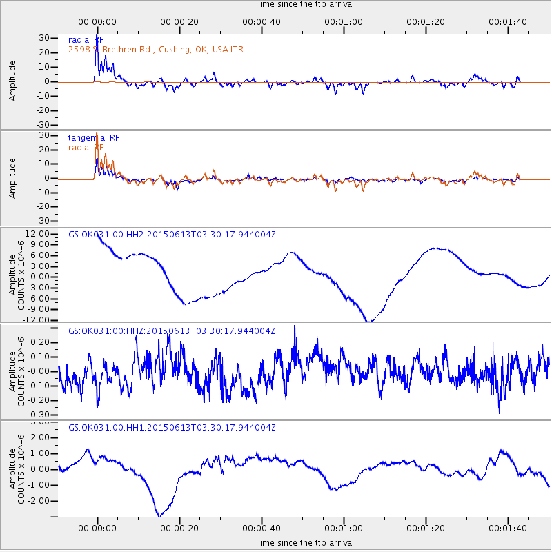
Signal To Noise
| Channel | StoN | STA | LTA |
| GS:OK031:00:HHZ:20150613T03:30:17.944004Z | 1.2128391 | 1.014608E-7 | 8.3655614E-8 |
| GS:OK031:00:HH1:20150613T03:30:17.944004Z | 0.7744679 | 5.877883E-7 | 7.589576E-7 |
| GS:OK031:00:HH2:20150613T03:30:17.944004Z | 0.9819269 | 5.703012E-6 | 5.80798E-6 |
| Arrivals |
| Ps | 3.8 SECOND |
| PpPs | 15 SECOND |
| PsPs/PpSs | 19 SECOND |


