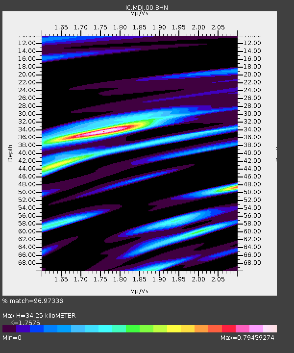
MDJ Mudanjiang, Heilongjiang Province, China - Earthquake Result Viewer

Earthquake location: Southern Sumatra, Indonesia
Earthquake latitude/longitude: -2.2/99.8
Earthquake time(UTC): 2008/02/25 (056) 21:02:18 GMT
Earthquake Depth: 25 km
Earthquake Magnitude: 6.2 MB, 6.6 MS, 6.6 MW, 6.5 MW
Earthquake Catalog/Contributor: WHDF/NEIC
Network: IC New China Digital Seismograph Network
Station: MDJ Mudanjiang, Heilongjiang Province, China
Lat/Lon: 44.62 N/129.59 E
Elevation: 250 m
Distance: 53.7 deg
Az: 26.119 deg
Baz: 218.021 deg
Ray Param: 0.06589064
Estimated Moho Depth: 34.25 km
Estimated Crust Vp/Vs: 1.76
Assumed Crust Vp: 6.459 km/s
Estimated Crust Vs: 3.675 km/s
Estimated Crust Poisson's Ratio: 0.26
Radial Match: 96.97336 %
Radial Bump: 400
Transverse Match: 81.810844 %
Transverse Bump: 400
SOD ConfigId: 2564
Insert Time: 2010-03-04 23:11:14.672 +0000
GWidth: 2.5
Max Bumps: 400
Tol: 0.001

Signal To Noise

ChannelStoNSTALTA
IC:MDJ:00:BHN:20080225T21:11:07.222002Z12.5808592.4009184E-61.9083899E-7
IC:MDJ:00:BHE:20080225T21:11:07.222002Z16.5191232.0422094E-61.2362699E-7
IC:MDJ:00:BHZ:20080225T21:11:07.222002Z30.048575.874731E-61.9550784E-7
Arrivals
Ps4.2 SECOND
PpPs14 SECOND
PsPs/PpSs18 SECOND