You are here: Home > Network List > IC - New China Digital Seismograph Network Stations List
> Station MDJ Mudanjiang, Heilongjiang Province, China > Earthquake Result Viewer
MDJ Mudanjiang, Heilongjiang Province, China - Earthquake Result Viewer
| Earthquake location: |
Northern Sumatra, Indonesia |
| Earthquake latitude/longitude: |
1.0/97.4 |
| Earthquake time(UTC): |
2008/01/22 (022) 17:14:57 GMT |
| Earthquake Depth: |
20 km |
| Earthquake Magnitude: |
5.9 MB, 6.2 MW, 6.1 MW |
| Earthquake Catalog/Contributor: |
WHDF/NEIC |
|
| Network: |
IC New China Digital Seismograph Network |
| Station: |
MDJ Mudanjiang, Heilongjiang Province, China |
| Lat/Lon: |
44.62 N/129.59 E |
| Elevation: |
250 m |
|
| Distance: |
51.9 deg |
| Az: |
28.871 deg |
| Baz: |
222.53 deg |
| Ray Param: |
0.06707459 |
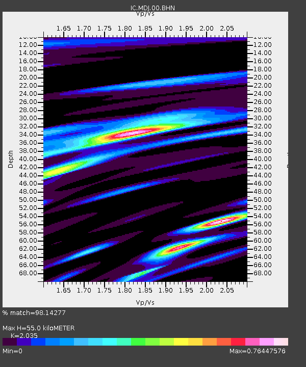
| Estimated Moho Depth: |
55.0 km |
| Estimated Crust Vp/Vs: |
2.04 |
| Assumed Crust Vp: |
6.459 km/s |
| Estimated Crust Vs: |
3.174 km/s |
| Estimated Crust Poisson's Ratio: |
0.34 |
|
| Radial Match: |
98.14277 % |
| Radial Bump: |
312 |
| Transverse Match: |
87.37788 % |
| Transverse Bump: |
400 |
| SOD ConfigId: |
2564 |
| Insert Time: |
2010-03-04 23:11:25.872 +0000 |
| GWidth: |
2.5 |
| Max Bumps: |
400 |
| Tol: |
0.001 |
|

Signal To Noise
| Channel | StoN | STA | LTA |
| IC:MDJ:00:BHN:20080122T17:23:34.285022Z | 16.382475 | 1.4051794E-6 | 8.577333E-8 |
| IC:MDJ:00:BHE:20080122T17:23:34.285022Z | 30.635002 | 1.457053E-6 | 4.756171E-8 |
| IC:MDJ:00:BHZ:20080122T17:23:34.285022Z | 42.09549 | 3.645214E-6 | 8.6593936E-8 |
| Arrivals |
| Ps | 9.3 SECOND |
| PpPs | 25 SECOND |
| PsPs/PpSs | 34 SECOND |


