You are here: Home > Network List > TA - USArray Transportable Network (new EarthScope stations) Stations List
> Station J20K Nowitna River, AK, USA > Earthquake Result Viewer
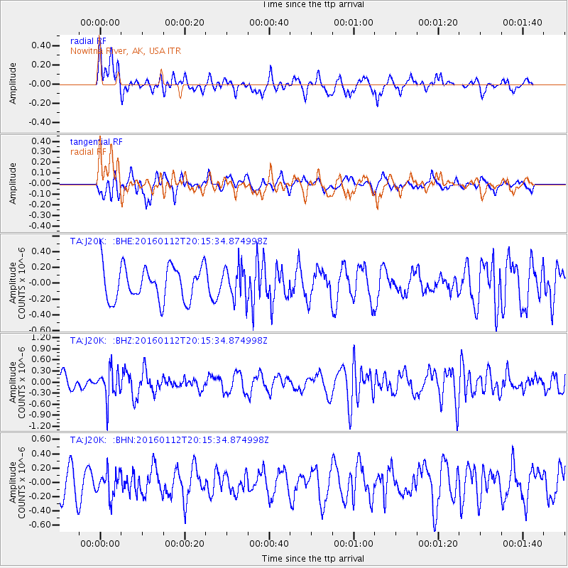
J20K Nowitna River, AK, USA - Earthquake Result Viewer
*The percent match for this event was below the threshold and hence no stack was calculated.
| Earthquake location: |
Hindu Kush Region, Afghanistan |
| Earthquake latitude/longitude: |
36.6/71.0 |
| Earthquake time(UTC): |
2016/01/12 (012) 20:04:59 GMT |
| Earthquake Depth: |
239 km |
| Earthquake Magnitude: |
5.7 MWW, 5.7 MWB, 5.7 MWC |
| Earthquake Catalog/Contributor: |
NEIC PDE/NEIC COMCAT |
|
| Network: |
TA USArray Transportable Network (new EarthScope stations) |
| Station: |
J20K Nowitna River, AK, USA |
| Lat/Lon: |
64.18 N/154.15 W |
| Elevation: |
314 m |
|
| Distance: |
73.5 deg |
| Az: |
18.882 deg |
| Baz: |
323.499 deg |
| Ray Param: |
$rayparam |
*The percent match for this event was below the threshold and hence was not used in the summary stack. |
|
| Radial Match: |
60.97192 % |
| Radial Bump: |
400 |
| Transverse Match: |
46.12729 % |
| Transverse Bump: |
400 |
| SOD ConfigId: |
7422571 |
| Insert Time: |
2019-04-21 17:42:56.802 +0000 |
| GWidth: |
2.5 |
| Max Bumps: |
400 |
| Tol: |
0.001 |
|
Signal To Noise
| Channel | StoN | STA | LTA |
| TA:J20K: :BHZ:20160112T20:15:34.874998Z | 2.3790178 | 3.9565478E-7 | 1.6631014E-7 |
| TA:J20K: :BHN:20160112T20:15:34.874998Z | 0.77701956 | 1.712878E-7 | 2.2044208E-7 |
| TA:J20K: :BHE:20160112T20:15:34.874998Z | 0.97155195 | 2.0704735E-7 | 2.1310991E-7 |
| Arrivals |
| Ps | |
| PpPs | |
| PsPs/PpSs | |


