You are here: Home > Network List > IC - New China Digital Seismograph Network Stations List
> Station MDJ Mudanjiang, Heilongjiang Province, China > Earthquake Result Viewer
MDJ Mudanjiang, Heilongjiang Province, China - Earthquake Result Viewer
| Earthquake location: |
Santa Cruz Islands Region |
| Earthquake latitude/longitude: |
-11.0/164.5 |
| Earthquake time(UTC): |
2008/07/19 (201) 09:27:01 GMT |
| Earthquake Depth: |
11 km |
| Earthquake Magnitude: |
6.1 MB, 6.4 MS, 6.6 MW, 6.6 MW |
| Earthquake Catalog/Contributor: |
WHDF/NEIC |
|
| Network: |
IC New China Digital Seismograph Network |
| Station: |
MDJ Mudanjiang, Heilongjiang Province, China |
| Lat/Lon: |
44.62 N/129.59 E |
| Elevation: |
250 m |
|
| Distance: |
63.8 deg |
| Az: |
332.903 deg |
| Baz: |
141.234 deg |
| Ray Param: |
0.05935299 |
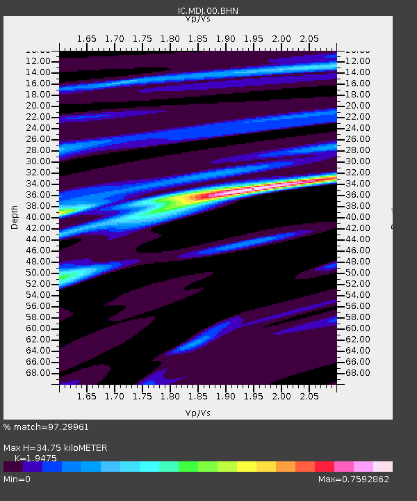
| Estimated Moho Depth: |
34.75 km |
| Estimated Crust Vp/Vs: |
1.95 |
| Assumed Crust Vp: |
6.459 km/s |
| Estimated Crust Vs: |
3.317 km/s |
| Estimated Crust Poisson's Ratio: |
0.32 |
|
| Radial Match: |
97.29961 % |
| Radial Bump: |
329 |
| Transverse Match: |
95.223755 % |
| Transverse Bump: |
400 |
| SOD ConfigId: |
2658 |
| Insert Time: |
2010-03-04 23:11:39.461 +0000 |
| GWidth: |
2.5 |
| Max Bumps: |
400 |
| Tol: |
0.001 |
|

Signal To Noise
| Channel | StoN | STA | LTA |
| IC:MDJ:00:BHN:20080719T09:37:02.23301Z | 20.205093 | 1.8429226E-6 | 9.1210794E-8 |
| IC:MDJ:00:BHE:20080719T09:37:02.23301Z | 4.6638007 | 5.967188E-7 | 1.279469E-7 |
| IC:MDJ:00:BHZ:20080719T09:37:02.23301Z | 3.8587303 | 4.0180564E-7 | 1.0412897E-7 |
| Arrivals |
| Ps | 5.3 SECOND |
| PpPs | 15 SECOND |
| PsPs/PpSs | 21 SECOND |


