You are here: Home > Network List > YY13 - Exploring extensional tectonics beyond the Ethiopian Rift Stations List
> Station GORE District Admin Buildg, Gore, Ethiopia > Earthquake Result Viewer
GORE District Admin Buildg, Gore, Ethiopia - Earthquake Result Viewer
| Earthquake location: |
Hindu Kush Region, Afghanistan |
| Earthquake latitude/longitude: |
36.6/71.0 |
| Earthquake time(UTC): |
2016/01/12 (012) 20:04:59 GMT |
| Earthquake Depth: |
239 km |
| Earthquake Magnitude: |
5.7 MWW, 5.7 MWB, 5.7 MWC |
| Earthquake Catalog/Contributor: |
NEIC PDE/NEIC COMCAT |
|
| Network: |
YY Exploring extensional tectonics beyond the Ethiopian Rift |
| Station: |
GORE District Admin Buildg, Gore, Ethiopia |
| Lat/Lon: |
8.15 N/35.53 E |
| Elevation: |
2064 m |
|
| Distance: |
42.9 deg |
| Az: |
237.524 deg |
| Baz: |
43.312 deg |
| Ray Param: |
0.071953245 |
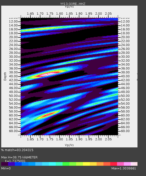
| Estimated Moho Depth: |
38.75 km |
| Estimated Crust Vp/Vs: |
1.74 |
| Assumed Crust Vp: |
6.464 km/s |
| Estimated Crust Vs: |
3.72 km/s |
| Estimated Crust Poisson's Ratio: |
0.25 |
|
| Radial Match: |
83.204315 % |
| Radial Bump: |
400 |
| Transverse Match: |
64.835236 % |
| Transverse Bump: |
400 |
| SOD ConfigId: |
7422571 |
| Insert Time: |
2019-04-21 17:43:57.200 +0000 |
| GWidth: |
2.5 |
| Max Bumps: |
400 |
| Tol: |
0.001 |
|

Signal To Noise
| Channel | StoN | STA | LTA |
| YY:GORE: :HHZ:20160112T20:12:03.919004Z | 22.895195 | 1.0211832E-6 | 4.4602505E-8 |
| YY:GORE: :HHN:20160112T20:12:03.919004Z | 3.8809686 | 5.7411734E-7 | 1.4793146E-7 |
| YY:GORE: :HHE:20160112T20:12:03.919004Z | 7.4983764 | 4.3953162E-7 | 5.8616905E-8 |
| Arrivals |
| Ps | 4.7 SECOND |
| PpPs | 15 SECOND |
| PsPs/PpSs | 20 SECOND |


