You are here: Home > Network List > AK - Alaska Regional Network Stations List
> Station MDM Murphy Dome > Earthquake Result Viewer
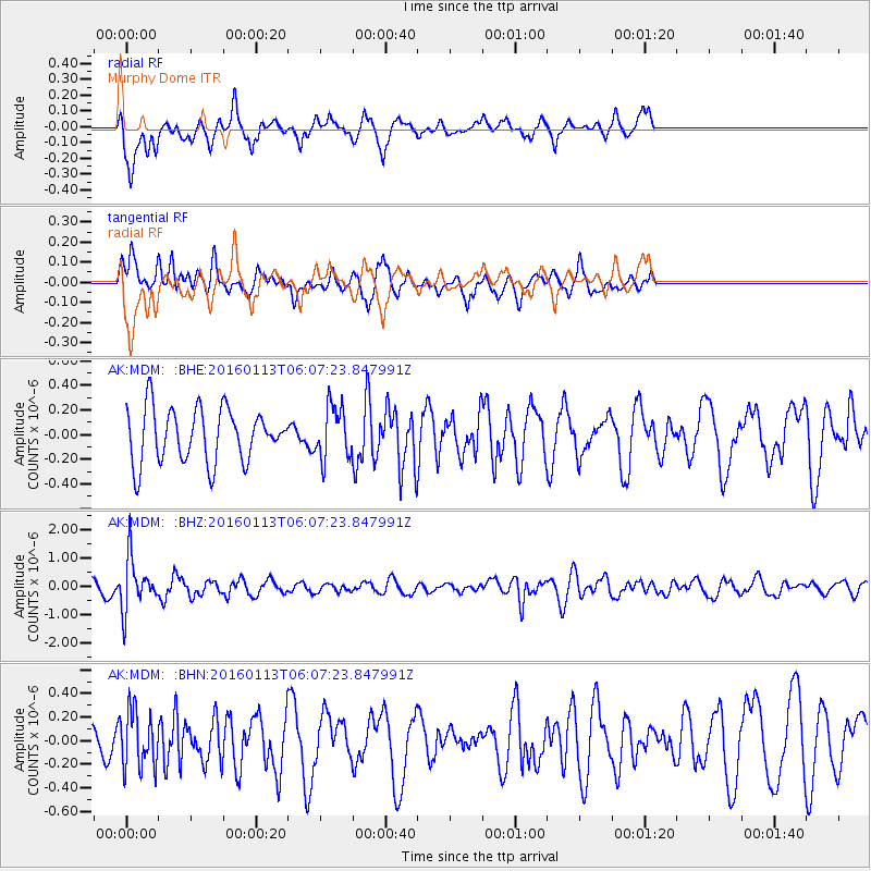
MDM Murphy Dome - Earthquake Result Viewer
*The percent match for this event was below the threshold and hence no stack was calculated.
| Earthquake location: |
Tonga Islands |
| Earthquake latitude/longitude: |
-15.2/-174.9 |
| Earthquake time(UTC): |
2016/01/13 (013) 05:55:59 GMT |
| Earthquake Depth: |
233 km |
| Earthquake Magnitude: |
5.8 MB |
| Earthquake Catalog/Contributor: |
NEIC PDE/NEIC COMCAT |
|
| Network: |
AK Alaska Regional Network |
| Station: |
MDM Murphy Dome |
| Lat/Lon: |
64.96 N/148.23 W |
| Elevation: |
634 m |
|
| Distance: |
82.4 deg |
| Az: |
11.112 deg |
| Baz: |
205.925 deg |
| Ray Param: |
$rayparam |
*The percent match for this event was below the threshold and hence was not used in the summary stack. |
|
| Radial Match: |
45.64945 % |
| Radial Bump: |
311 |
| Transverse Match: |
45.67762 % |
| Transverse Bump: |
345 |
| SOD ConfigId: |
7422571 |
| Insert Time: |
2019-04-21 17:44:53.411 +0000 |
| GWidth: |
2.5 |
| Max Bumps: |
400 |
| Tol: |
0.001 |
|
Signal To Noise
| Channel | StoN | STA | LTA |
| AK:MDM: :BHZ:20160113T06:07:23.847991Z | 5.919566 | 9.1131824E-7 | 1.5395017E-7 |
| AK:MDM: :BHN:20160113T06:07:23.847991Z | 1.265308 | 2.4783037E-7 | 1.9586562E-7 |
| AK:MDM: :BHE:20160113T06:07:23.847991Z | 1.1295792 | 2.421508E-7 | 2.1437258E-7 |
| Arrivals |
| Ps | |
| PpPs | |
| PsPs/PpSs | |


