You are here: Home > Network List > US - United States National Seismic Network Stations List
> Station AMTX Amarillo, Texas, USA > Earthquake Result Viewer
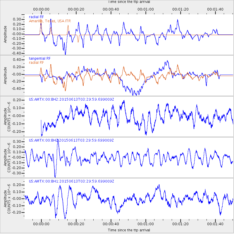
AMTX Amarillo, Texas, USA - Earthquake Result Viewer
*The percent match for this event was below the threshold and hence no stack was calculated.
| Earthquake location: |
South Of Fiji Islands |
| Earthquake latitude/longitude: |
-24.6/-176.2 |
| Earthquake time(UTC): |
2015/06/13 (164) 03:17:24 GMT |
| Earthquake Depth: |
22 km |
| Earthquake Magnitude: |
5.5 MWW, 5.5 MWB, 5.6 MWC |
| Earthquake Catalog/Contributor: |
NEIC PDE/NEIC COMCAT |
|
| Network: |
US United States National Seismic Network |
| Station: |
AMTX Amarillo, Texas, USA |
| Lat/Lon: |
34.53 N/101.41 W |
| Elevation: |
1010 m |
|
| Distance: |
92.1 deg |
| Az: |
52.855 deg |
| Baz: |
241.516 deg |
| Ray Param: |
$rayparam |
*The percent match for this event was below the threshold and hence was not used in the summary stack. |
|
| Radial Match: |
63.097847 % |
| Radial Bump: |
400 |
| Transverse Match: |
37.26456 % |
| Transverse Bump: |
400 |
| SOD ConfigId: |
976571 |
| Insert Time: |
2015-07-17 00:16:33.873 +0000 |
| GWidth: |
2.5 |
| Max Bumps: |
400 |
| Tol: |
0.001 |
|
Signal To Noise
| Channel | StoN | STA | LTA |
| US:AMTX:00:BHZ:20150613T03:29:59.699009Z | 1.0344971 | 7.7977305E-8 | 7.537702E-8 |
| US:AMTX:00:BH1:20150613T03:29:59.699009Z | 0.43415964 | 7.151001E-8 | 1.6470902E-7 |
| US:AMTX:00:BH2:20150613T03:29:59.699009Z | 0.76954085 | 6.624731E-8 | 8.608681E-8 |
| Arrivals |
| Ps | |
| PpPs | |
| PsPs/PpSs | |


