You are here: Home > Network List > CI - Caltech Regional Seismic Network Stations List
> Station TIN Tinemaha, Big Pine, CA, USA > Earthquake Result Viewer
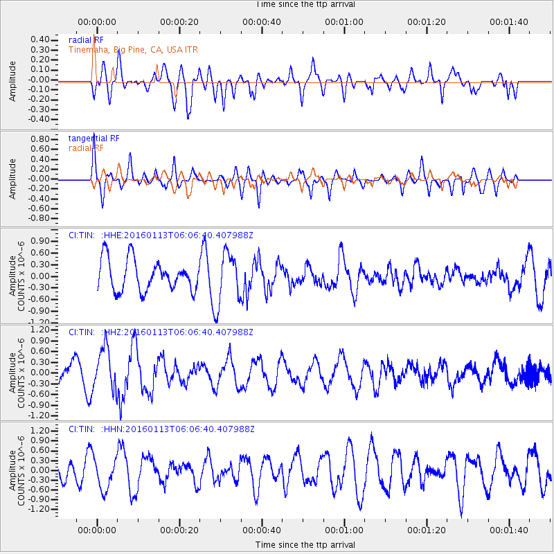
TIN Tinemaha, Big Pine, CA, USA - Earthquake Result Viewer
*The percent match for this event was below the threshold and hence no stack was calculated.
| Earthquake location: |
Tonga Islands |
| Earthquake latitude/longitude: |
-15.2/-174.9 |
| Earthquake time(UTC): |
2016/01/13 (013) 05:55:59 GMT |
| Earthquake Depth: |
233 km |
| Earthquake Magnitude: |
5.8 MB |
| Earthquake Catalog/Contributor: |
NEIC PDE/NEIC COMCAT |
|
| Network: |
CI Caltech Regional Seismic Network |
| Station: |
TIN Tinemaha, Big Pine, CA, USA |
| Lat/Lon: |
37.05 N/118.23 W |
| Elevation: |
1197 m |
|
| Distance: |
74.4 deg |
| Az: |
43.934 deg |
| Baz: |
236.861 deg |
| Ray Param: |
$rayparam |
*The percent match for this event was below the threshold and hence was not used in the summary stack. |
|
| Radial Match: |
45.28502 % |
| Radial Bump: |
400 |
| Transverse Match: |
69.733284 % |
| Transverse Bump: |
400 |
| SOD ConfigId: |
7422571 |
| Insert Time: |
2019-04-21 17:46:48.733 +0000 |
| GWidth: |
2.5 |
| Max Bumps: |
400 |
| Tol: |
0.001 |
|
Signal To Noise
| Channel | StoN | STA | LTA |
| CI:TIN: :HHZ:20160113T06:06:40.407988Z | 1.8623638 | 6.05257E-7 | 3.2499395E-7 |
| CI:TIN: :HHN:20160113T06:06:40.407988Z | 0.9832202 | 4.7059362E-7 | 4.786248E-7 |
| CI:TIN: :HHE:20160113T06:06:40.407988Z | 1.3038445 | 5.329842E-7 | 4.0877896E-7 |
| Arrivals |
| Ps | |
| PpPs | |
| PsPs/PpSs | |


