You are here: Home > Network List > TA - USArray Transportable Network (new EarthScope stations) Stations List
> Station J26L Joseph Creek, AK, USA > Earthquake Result Viewer
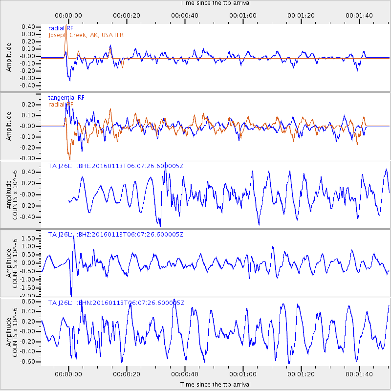
J26L Joseph Creek, AK, USA - Earthquake Result Viewer
*The percent match for this event was below the threshold and hence no stack was calculated.
| Earthquake location: |
Tonga Islands |
| Earthquake latitude/longitude: |
-15.2/-174.9 |
| Earthquake time(UTC): |
2016/01/13 (013) 05:55:59 GMT |
| Earthquake Depth: |
233 km |
| Earthquake Magnitude: |
5.8 MB |
| Earthquake Catalog/Contributor: |
NEIC PDE/NEIC COMCAT |
|
| Network: |
TA USArray Transportable Network (new EarthScope stations) |
| Station: |
J26L Joseph Creek, AK, USA |
| Lat/Lon: |
64.50 N/143.56 W |
| Elevation: |
1144 m |
|
| Distance: |
83.0 deg |
| Az: |
13.11 deg |
| Baz: |
210.392 deg |
| Ray Param: |
$rayparam |
*The percent match for this event was below the threshold and hence was not used in the summary stack. |
|
| Radial Match: |
59.450096 % |
| Radial Bump: |
400 |
| Transverse Match: |
66.1197 % |
| Transverse Bump: |
369 |
| SOD ConfigId: |
7422571 |
| Insert Time: |
2019-04-21 17:49:51.317 +0000 |
| GWidth: |
2.5 |
| Max Bumps: |
400 |
| Tol: |
0.001 |
|
Signal To Noise
| Channel | StoN | STA | LTA |
| TA:J26L: :BHZ:20160113T06:07:26.600005Z | 3.9144962 | 7.812541E-7 | 1.9957972E-7 |
| TA:J26L: :BHN:20160113T06:07:26.600005Z | 1.4939095 | 3.0316454E-7 | 2.0293368E-7 |
| TA:J26L: :BHE:20160113T06:07:26.600005Z | 2.2420526 | 3.4643844E-7 | 1.5451843E-7 |
| Arrivals |
| Ps | |
| PpPs | |
| PsPs/PpSs | |


