You are here: Home > Network List > TA - USArray Transportable Network (new EarthScope stations) Stations List
> Station L20K Farewell, AK, USA > Earthquake Result Viewer
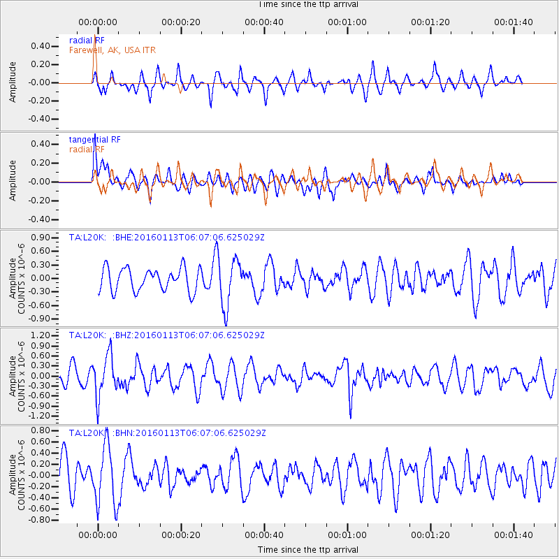
L20K Farewell, AK, USA - Earthquake Result Viewer
*The percent match for this event was below the threshold and hence no stack was calculated.
| Earthquake location: |
Tonga Islands |
| Earthquake latitude/longitude: |
-15.2/-174.9 |
| Earthquake time(UTC): |
2016/01/13 (013) 05:55:59 GMT |
| Earthquake Depth: |
233 km |
| Earthquake Magnitude: |
5.8 MB |
| Earthquake Catalog/Contributor: |
NEIC PDE/NEIC COMCAT |
|
| Network: |
TA USArray Transportable Network (new EarthScope stations) |
| Station: |
L20K Farewell, AK, USA |
| Lat/Lon: |
62.48 N/153.88 W |
| Elevation: |
673 m |
|
| Distance: |
79.2 deg |
| Az: |
9.768 deg |
| Baz: |
200.648 deg |
| Ray Param: |
$rayparam |
*The percent match for this event was below the threshold and hence was not used in the summary stack. |
|
| Radial Match: |
63.32485 % |
| Radial Bump: |
392 |
| Transverse Match: |
42.83651 % |
| Transverse Bump: |
400 |
| SOD ConfigId: |
7422571 |
| Insert Time: |
2019-04-21 17:49:54.775 +0000 |
| GWidth: |
2.5 |
| Max Bumps: |
400 |
| Tol: |
0.001 |
|
Signal To Noise
| Channel | StoN | STA | LTA |
| TA:L20K: :BHZ:20160113T06:07:06.625029Z | 2.001359 | 6.332301E-7 | 3.1640005E-7 |
| TA:L20K: :BHN:20160113T06:07:06.625029Z | 1.6470671 | 5.560709E-7 | 3.376128E-7 |
| TA:L20K: :BHE:20160113T06:07:06.625029Z | 2.0756993 | 5.1170485E-7 | 2.4652167E-7 |
| Arrivals |
| Ps | |
| PpPs | |
| PsPs/PpSs | |


