You are here: Home > Network List > CI - Caltech Regional Seismic Network Stations List
> Station MPP McPhearson Peak > Earthquake Result Viewer
MPP McPhearson Peak - Earthquake Result Viewer
*The percent match for this event was below the threshold and hence no stack was calculated.
| Earthquake location: |
Southern Bolivia |
| Earthquake latitude/longitude: |
-19.8/-63.3 |
| Earthquake time(UTC): |
2016/01/14 (014) 03:25:28 GMT |
| Earthquake Depth: |
582 km |
| Earthquake Magnitude: |
6.1 MWW, 6.1 MWB |
| Earthquake Catalog/Contributor: |
NEIC PDE/NEIC COMCAT |
|
| Network: |
CI Caltech Regional Seismic Network |
| Station: |
MPP McPhearson Peak |
| Lat/Lon: |
34.89 N/119.81 W |
| Elevation: |
1739 m |
|
| Distance: |
76.4 deg |
| Az: |
315.133 deg |
| Baz: |
126.107 deg |
| Ray Param: |
$rayparam |
*The percent match for this event was below the threshold and hence was not used in the summary stack. |
|
| Radial Match: |
65.70663 % |
| Radial Bump: |
400 |
| Transverse Match: |
59.94054 % |
| Transverse Bump: |
400 |
| SOD ConfigId: |
7422571 |
| Insert Time: |
2019-04-21 17:59:40.297 +0000 |
| GWidth: |
2.5 |
| Max Bumps: |
400 |
| Tol: |
0.001 |
|
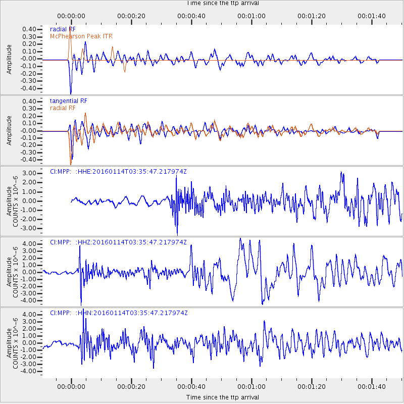
Signal To Noise
| Channel | StoN | STA | LTA |
| CI:MPP: :HHZ:20160114T03:35:47.217974Z | 3.0436044 | 1.3196515E-6 | 4.3358182E-7 |
| CI:MPP: :HHN:20160114T03:35:47.217974Z | 1.9605982 | 1.3946743E-6 | 7.113514E-7 |
| CI:MPP: :HHE:20160114T03:35:47.217974Z | 2.9859672 | 8.1430704E-7 | 2.7271133E-7 |
| Arrivals |
| Ps | |
| PpPs | |
| PsPs/PpSs | |


