You are here: Home > Network List > IC - New China Digital Seismograph Network Stations List
> Station MDJ Mudanjiang, Heilongjiang Province, China > Earthquake Result Viewer
MDJ Mudanjiang, Heilongjiang Province, China - Earthquake Result Viewer

| Earthquake location: |
Northern Molucca Sea |
| Earthquake latitude/longitude: |
1.1/126.3 |
| Earthquake time(UTC): |
2007/01/21 (021) 11:27:45 GMT |
| Earthquake Depth: |
22 km |
| Earthquake Magnitude: |
6.7 MB, 7.3 MS, 7.5 MW, 7.3 MW |
| Earthquake Catalog/Contributor: |
WHDF/NEIC |
|
| Network: |
IC New China Digital Seismograph Network |
| Station: |
MDJ Mudanjiang, Heilongjiang Province, China |
| Lat/Lon: |
44.62 N/129.59 E |
| Elevation: |
250 m |
|
| Distance: |
43.5 deg |
| Az: |
3.436 deg |
| Baz: |
184.814 deg |
| Ray Param: |
0.07250175 |
| Estimated Moho Depth: |
36.5 km |
| Estimated Crust Vp/Vs: |
1.82 |
| Assumed Crust Vp: |
6.459 km/s |
| Estimated Crust Vs: |
3.559 km/s |
| Estimated Crust Poisson's Ratio: |
0.28 |
|
| Radial Match: |
96.75099 % |
| Radial Bump: |
348 |
| Transverse Match: |
89.7353 % |
| Transverse Bump: |
400 |
| SOD ConfigId: |
2564 |
| Insert Time: |
2010-03-04 23:14:47.569 +0000 |
| GWidth: |
2.5 |
| Max Bumps: |
400 |
| Tol: |
0.001 |
|
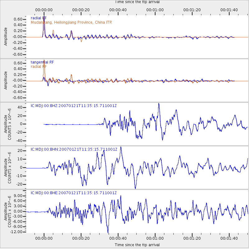
Signal To Noise
| Channel | StoN | STA | LTA |
| IC:MDJ:00:BHN:20070121T11:35:15.711001Z | 35.133133 | 2.752141E-6 | 7.833463E-8 |
| IC:MDJ:00:BHE:20070121T11:35:15.711001Z | 15.172381 | 7.196984E-7 | 4.743477E-8 |
| IC:MDJ:00:BHZ:20070121T11:35:15.711001Z | 63.98848 | 5.5845658E-6 | 8.727454E-8 |
| Arrivals |
| Ps | 4.9 SECOND |
| PpPs | 15 SECOND |
| PsPs/PpSs | 20 SECOND |


