You are here: Home > Network List > TA - USArray Transportable Network (new EarthScope stations) Stations List
> Station 121A Cookes Peak, Deming, NM, USA > Earthquake Result Viewer
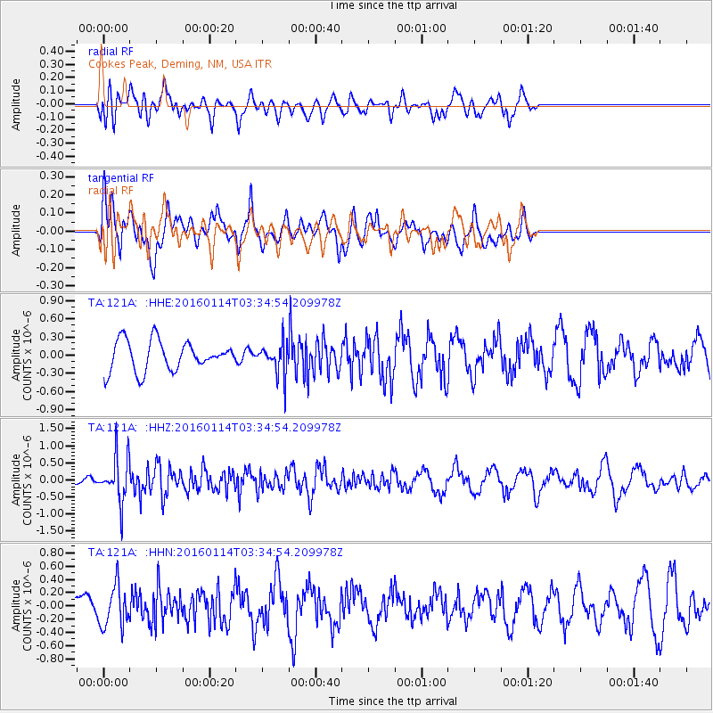
121A Cookes Peak, Deming, NM, USA - Earthquake Result Viewer
*The percent match for this event was below the threshold and hence no stack was calculated.
| Earthquake location: |
Southern Bolivia |
| Earthquake latitude/longitude: |
-19.8/-63.3 |
| Earthquake time(UTC): |
2016/01/14 (014) 03:25:28 GMT |
| Earthquake Depth: |
582 km |
| Earthquake Magnitude: |
6.1 MWW, 6.1 MWB |
| Earthquake Catalog/Contributor: |
NEIC PDE/NEIC COMCAT |
|
| Network: |
TA USArray Transportable Network (new EarthScope stations) |
| Station: |
121A Cookes Peak, Deming, NM, USA |
| Lat/Lon: |
32.53 N/107.79 W |
| Elevation: |
1652 m |
|
| Distance: |
67.2 deg |
| Az: |
320.056 deg |
| Baz: |
134.311 deg |
| Ray Param: |
$rayparam |
*The percent match for this event was below the threshold and hence was not used in the summary stack. |
|
| Radial Match: |
44.358753 % |
| Radial Bump: |
400 |
| Transverse Match: |
58.580406 % |
| Transverse Bump: |
400 |
| SOD ConfigId: |
7422571 |
| Insert Time: |
2019-04-21 18:06:25.171 +0000 |
| GWidth: |
2.5 |
| Max Bumps: |
400 |
| Tol: |
0.001 |
|
Signal To Noise
| Channel | StoN | STA | LTA |
| TA:121A: :HHZ:20160114T03:34:54.209978Z | 5.5212793 | 6.602308E-7 | 1.1957931E-7 |
| TA:121A: :HHN:20160114T03:34:54.209978Z | 1.2893026 | 3.1318834E-7 | 2.42913E-7 |
| TA:121A: :HHE:20160114T03:34:54.209978Z | 1.350277 | 3.2369468E-7 | 2.3972467E-7 |
| Arrivals |
| Ps | |
| PpPs | |
| PsPs/PpSs | |


