You are here: Home > Network List > TA - USArray Transportable Network (new EarthScope stations) Stations List
> Station O03E Paynes Creek, CA, USA > Earthquake Result Viewer
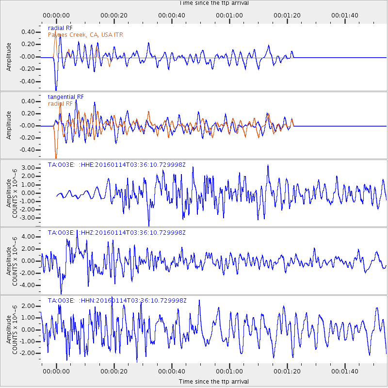
O03E Paynes Creek, CA, USA - Earthquake Result Viewer
*The percent match for this event was below the threshold and hence no stack was calculated.
| Earthquake location: |
Southern Bolivia |
| Earthquake latitude/longitude: |
-19.8/-63.3 |
| Earthquake time(UTC): |
2016/01/14 (014) 03:25:28 GMT |
| Earthquake Depth: |
582 km |
| Earthquake Magnitude: |
6.1 MWW, 6.1 MWB |
| Earthquake Catalog/Contributor: |
NEIC PDE/NEIC COMCAT |
|
| Network: |
TA USArray Transportable Network (new EarthScope stations) |
| Station: |
O03E Paynes Creek, CA, USA |
| Lat/Lon: |
40.29 N/121.80 W |
| Elevation: |
967 m |
|
| Distance: |
80.9 deg |
| Az: |
318.649 deg |
| Baz: |
125.591 deg |
| Ray Param: |
$rayparam |
*The percent match for this event was below the threshold and hence was not used in the summary stack. |
|
| Radial Match: |
68.26963 % |
| Radial Bump: |
400 |
| Transverse Match: |
67.544556 % |
| Transverse Bump: |
398 |
| SOD ConfigId: |
7422571 |
| Insert Time: |
2019-04-21 18:06:47.317 +0000 |
| GWidth: |
2.5 |
| Max Bumps: |
400 |
| Tol: |
0.001 |
|
Signal To Noise
| Channel | StoN | STA | LTA |
| TA:O03E: :HHZ:20160114T03:36:10.729998Z | 2.8643882 | 2.5142976E-6 | 8.777783E-7 |
| TA:O03E: :HHN:20160114T03:36:10.729998Z | 2.072258 | 1.1256751E-6 | 5.432119E-7 |
| TA:O03E: :HHE:20160114T03:36:10.729998Z | 2.4440618 | 1.5987382E-6 | 6.5413167E-7 |
| Arrivals |
| Ps | |
| PpPs | |
| PsPs/PpSs | |


