You are here: Home > Network List > TA - USArray Transportable Network (new EarthScope stations) Stations List
> Station X43A Marvell, AR, USA > Earthquake Result Viewer
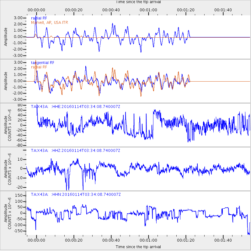
X43A Marvell, AR, USA - Earthquake Result Viewer
*The percent match for this event was below the threshold and hence no stack was calculated.
| Earthquake location: |
Southern Bolivia |
| Earthquake latitude/longitude: |
-19.8/-63.3 |
| Earthquake time(UTC): |
2016/01/14 (014) 03:25:28 GMT |
| Earthquake Depth: |
582 km |
| Earthquake Magnitude: |
6.1 MWW, 6.1 MWB |
| Earthquake Catalog/Contributor: |
NEIC PDE/NEIC COMCAT |
|
| Network: |
TA USArray Transportable Network (new EarthScope stations) |
| Station: |
X43A Marvell, AR, USA |
| Lat/Lon: |
34.52 N/90.88 W |
| Elevation: |
53 m |
|
| Distance: |
60.1 deg |
| Az: |
333.813 deg |
| Baz: |
149.791 deg |
| Ray Param: |
$rayparam |
*The percent match for this event was below the threshold and hence was not used in the summary stack. |
|
| Radial Match: |
43.02235 % |
| Radial Bump: |
369 |
| Transverse Match: |
40.52006 % |
| Transverse Bump: |
400 |
| SOD ConfigId: |
7422571 |
| Insert Time: |
2019-04-21 18:07:03.713 +0000 |
| GWidth: |
2.5 |
| Max Bumps: |
400 |
| Tol: |
0.001 |
|
Signal To Noise
| Channel | StoN | STA | LTA |
| TA:X43A: :HHZ:20160114T03:34:08.740007Z | 0.7074096 | 3.8571097E-6 | 5.4524417E-6 |
| TA:X43A: :HHN:20160114T03:34:08.740007Z | 0.39311668 | 3.5324458E-5 | 8.985744E-5 |
| TA:X43A: :HHE:20160114T03:34:08.740007Z | 0.92823404 | 1.9237237E-5 | 2.0724554E-5 |
| Arrivals |
| Ps | |
| PpPs | |
| PsPs/PpSs | |


