You are here: Home > Network List > IC - New China Digital Seismograph Network Stations List
> Station MDJ Mudanjiang, Heilongjiang Province, China > Earthquake Result Viewer
MDJ Mudanjiang, Heilongjiang Province, China - Earthquake Result Viewer
| Earthquake location: |
Eastern Kashmir |
| Earthquake latitude/longitude: |
35.3/78.1 |
| Earthquake time(UTC): |
1996/11/19 (324) 10:44:46 GMT |
| Earthquake Depth: |
33 km |
| Earthquake Magnitude: |
6.1 MB, 7.1 MS, 6.9 UNKNOWN, 6.8 MW |
| Earthquake Catalog/Contributor: |
WHDF/NEIC |
|
| Network: |
IC New China Digital Seismograph Network |
| Station: |
MDJ Mudanjiang, Heilongjiang Province, China |
| Lat/Lon: |
44.62 N/129.59 E |
| Elevation: |
250 m |
|
| Distance: |
39.9 deg |
| Az: |
60.507 deg |
| Baz: |
274.895 deg |
| Ray Param: |
0.07463019 |
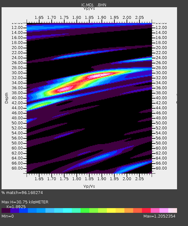
| Estimated Moho Depth: |
30.75 km |
| Estimated Crust Vp/Vs: |
1.89 |
| Assumed Crust Vp: |
6.459 km/s |
| Estimated Crust Vs: |
3.413 km/s |
| Estimated Crust Poisson's Ratio: |
0.31 |
|
| Radial Match: |
96.168274 % |
| Radial Bump: |
254 |
| Transverse Match: |
80.95409 % |
| Transverse Bump: |
400 |
| SOD ConfigId: |
4480 |
| Insert Time: |
2010-03-04 23:16:05.885 +0000 |
| GWidth: |
2.5 |
| Max Bumps: |
400 |
| Tol: |
0.001 |
|

Signal To Noise
| Channel | StoN | STA | LTA |
| IC:MDJ: :BHN:19961119T10:51:46.548004Z | 14.566057 | 1.581011E-6 | 1.0854077E-7 |
| IC:MDJ: :BHE:19961119T10:51:46.548004Z | 1.7576334 | 1.8054676E-7 | 1.0272151E-7 |
| IC:MDJ: :BHZ:19961119T10:51:46.548004Z | 13.405846 | 9.4799515E-7 | 7.071506E-8 |
| Arrivals |
| Ps | 4.5 SECOND |
| PpPs | 13 SECOND |
| PsPs/PpSs | 17 SECOND |


