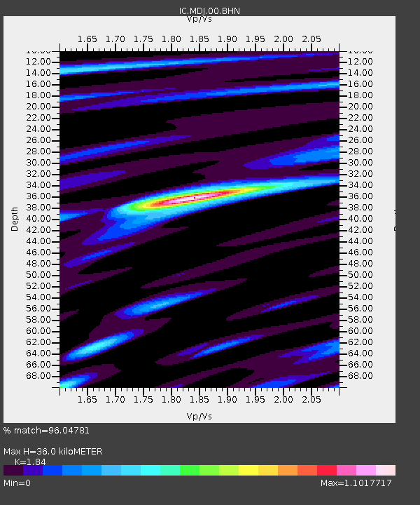
MDJ Mudanjiang, Heilongjiang Province, China - Earthquake Result Viewer
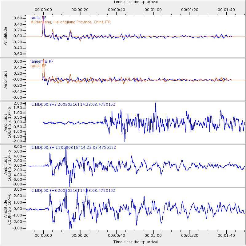
Earthquake location: Talaud Islands, Indonesia
Earthquake latitude/longitude: 3.8/126.6
Earthquake time(UTC): 2009/03/16 (075) 14:15:56 GMT
Earthquake Depth: 35 km
Earthquake Magnitude: 6.2 MB, 6.0 MS, 6.3 MW, 6.3 MW
Earthquake Catalog/Contributor: WHDF/NEIC
Network: IC New China Digital Seismograph Network
Station: MDJ Mudanjiang, Heilongjiang Province, China
Lat/Lon: 44.62 N/129.59 E
Elevation: 250 m
Distance: 40.7 deg
Az: 3.328 deg
Baz: 184.652 deg
Ray Param: 0.074157625
Estimated Moho Depth: 36.0 km
Estimated Crust Vp/Vs: 1.84
Assumed Crust Vp: 6.459 km/s
Estimated Crust Vs: 3.511 km/s
Estimated Crust Poisson's Ratio: 0.29
Radial Match: 96.04781 %
Radial Bump: 400
Transverse Match: 85.612755 %
Transverse Bump: 400
SOD ConfigId: 2658
Insert Time: 2010-03-04 23:16:16.308 +0000
GWidth: 2.5
Max Bumps: 400
Tol: 0.001

Signal To Noise

ChannelStoNSTALTA
IC:MDJ:00:BHN:20090316T14:23:03.475015Z29.1779271.6245449E-65.5677184E-8
IC:MDJ:00:BHE:20090316T14:23:03.475015Z8.9658418.200283E-79.146139E-8
IC:MDJ:00:BHZ:20090316T14:23:03.475015Z3.26378922.0147017E-76.172892E-8
Arrivals
Ps5.0 SECOND
PpPs15 SECOND
PsPs/PpSs20 SECOND