You are here: Home > Network List > AK - Alaska Regional Network Stations List
> Station TGL Tana Glacier > Earthquake Result Viewer
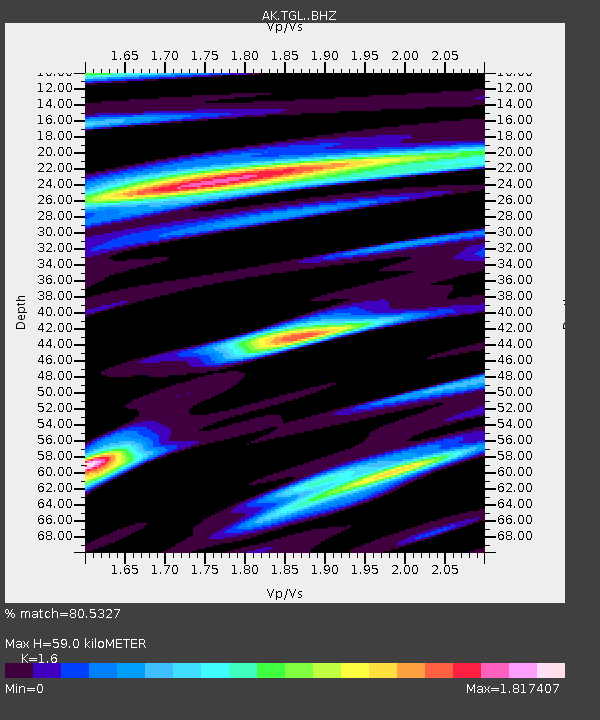
TGL Tana Glacier - Earthquake Result Viewer
| Earthquake location: |
Hokkaido, Japan Region |
| Earthquake latitude/longitude: |
42.0/142.7 |
| Earthquake time(UTC): |
2016/01/14 (014) 03:25:34 GMT |
| Earthquake Depth: |
51 km |
| Earthquake Magnitude: |
6.7 MWP, 6.7 MI |
| Earthquake Catalog/Contributor: |
NEIC PDE/NEIC COMCAT |
|
| Network: |
AK Alaska Regional Network |
| Station: |
TGL Tana Glacier |
| Lat/Lon: |
60.75 N/142.83 W |
| Elevation: |
1260 m |
|
| Distance: |
47.3 deg |
| Az: |
40.083 deg |
| Baz: |
282.009 deg |
| Ray Param: |
0.06995181 |
| Estimated Moho Depth: |
59.0 km |
| Estimated Crust Vp/Vs: |
1.60 |
| Assumed Crust Vp: |
6.566 km/s |
| Estimated Crust Vs: |
4.104 km/s |
| Estimated Crust Poisson's Ratio: |
0.18 |
|
| Radial Match: |
80.5327 % |
| Radial Bump: |
400 |
| Transverse Match: |
75.82466 % |
| Transverse Bump: |
400 |
| SOD ConfigId: |
7422571 |
| Insert Time: |
2019-04-21 18:12:10.781 +0000 |
| GWidth: |
2.5 |
| Max Bumps: |
400 |
| Tol: |
0.001 |
|

Signal To Noise
| Channel | StoN | STA | LTA |
| AK:TGL: :BHZ:20160114T03:33:31.608007Z | 5.1539865 | 2.0543428E-6 | 3.98593E-7 |
| AK:TGL: :BHN:20160114T03:33:31.608007Z | 2.707008 | 1.0010913E-6 | 3.698147E-7 |
| AK:TGL: :BHE:20160114T03:33:31.608007Z | 2.2498796 | 1.1942886E-6 | 5.3082334E-7 |
| Arrivals |
| Ps | 5.8 SECOND |
| PpPs | 22 SECOND |
| PsPs/PpSs | 28 SECOND |


