You are here: Home > Network List > AT - Alaska Tsunami Warning Seismic System Stations List
> Station SVW2 Sparrevohn, Alaska > Earthquake Result Viewer
SVW2 Sparrevohn, Alaska - Earthquake Result Viewer
| Earthquake location: |
Hokkaido, Japan Region |
| Earthquake latitude/longitude: |
42.0/142.7 |
| Earthquake time(UTC): |
2016/01/14 (014) 03:25:34 GMT |
| Earthquake Depth: |
51 km |
| Earthquake Magnitude: |
6.7 MWP, 6.7 MI |
| Earthquake Catalog/Contributor: |
NEIC PDE/NEIC COMCAT |
|
| Network: |
AT Alaska Tsunami Warning Seismic System |
| Station: |
SVW2 Sparrevohn, Alaska |
| Lat/Lon: |
61.11 N/155.62 W |
| Elevation: |
499 m |
|
| Distance: |
41.0 deg |
| Az: |
40.611 deg |
| Baz: |
271.212 deg |
| Ray Param: |
0.07389501 |
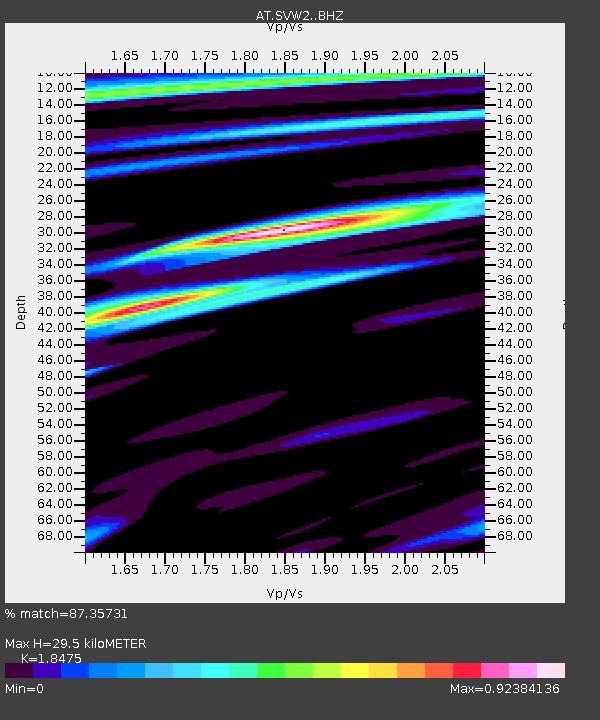
| Estimated Moho Depth: |
29.5 km |
| Estimated Crust Vp/Vs: |
1.85 |
| Assumed Crust Vp: |
6.566 km/s |
| Estimated Crust Vs: |
3.554 km/s |
| Estimated Crust Poisson's Ratio: |
0.29 |
|
| Radial Match: |
87.35731 % |
| Radial Bump: |
400 |
| Transverse Match: |
67.963135 % |
| Transverse Bump: |
400 |
| SOD ConfigId: |
7422571 |
| Insert Time: |
2019-04-21 18:12:20.790 +0000 |
| GWidth: |
2.5 |
| Max Bumps: |
400 |
| Tol: |
0.001 |
|

Signal To Noise
| Channel | StoN | STA | LTA |
| AT:SVW2: :BHZ:20160114T03:32:41.760015Z | 5.1281023 | 1.7014769E-6 | 3.3179467E-7 |
| AT:SVW2: :BHN:20160114T03:32:41.760015Z | 0.9937273 | 2.2582407E-7 | 2.2724953E-7 |
| AT:SVW2: :BHE:20160114T03:32:41.760015Z | 2.9770858 | 1.0646708E-6 | 3.5762181E-7 |
| Arrivals |
| Ps | 4.1 SECOND |
| PpPs | 12 SECOND |
| PsPs/PpSs | 16 SECOND |


