You are here: Home > Network List > AV - Alaska Volcano Observatory Stations List
> Station SPCN Ckakachatna North Broadband, Mount Spurr, Alaska > Earthquake Result Viewer
SPCN Ckakachatna North Broadband, Mount Spurr, Alaska - Earthquake Result Viewer

| Earthquake location: |
Hokkaido, Japan Region |
| Earthquake latitude/longitude: |
42.0/142.7 |
| Earthquake time(UTC): |
2016/01/14 (014) 03:25:34 GMT |
| Earthquake Depth: |
51 km |
| Earthquake Magnitude: |
6.7 MWP, 6.7 MI |
| Earthquake Catalog/Contributor: |
NEIC PDE/NEIC COMCAT |
|
| Network: |
AV Alaska Volcano Observatory |
| Station: |
SPCN Ckakachatna North Broadband, Mount Spurr, Alaska |
| Lat/Lon: |
61.22 N/152.19 W |
| Elevation: |
735 m |
|
| Distance: |
42.7 deg |
| Az: |
40.323 deg |
| Baz: |
274.004 deg |
| Ray Param: |
0.072877266 |
| Estimated Moho Depth: |
34.75 km |
| Estimated Crust Vp/Vs: |
1.66 |
| Assumed Crust Vp: |
6.566 km/s |
| Estimated Crust Vs: |
3.956 km/s |
| Estimated Crust Poisson's Ratio: |
0.22 |
|
| Radial Match: |
82.62524 % |
| Radial Bump: |
400 |
| Transverse Match: |
86.893326 % |
| Transverse Bump: |
400 |
| SOD ConfigId: |
7422571 |
| Insert Time: |
2019-04-21 18:12:52.729 +0000 |
| GWidth: |
2.5 |
| Max Bumps: |
400 |
| Tol: |
0.001 |
|
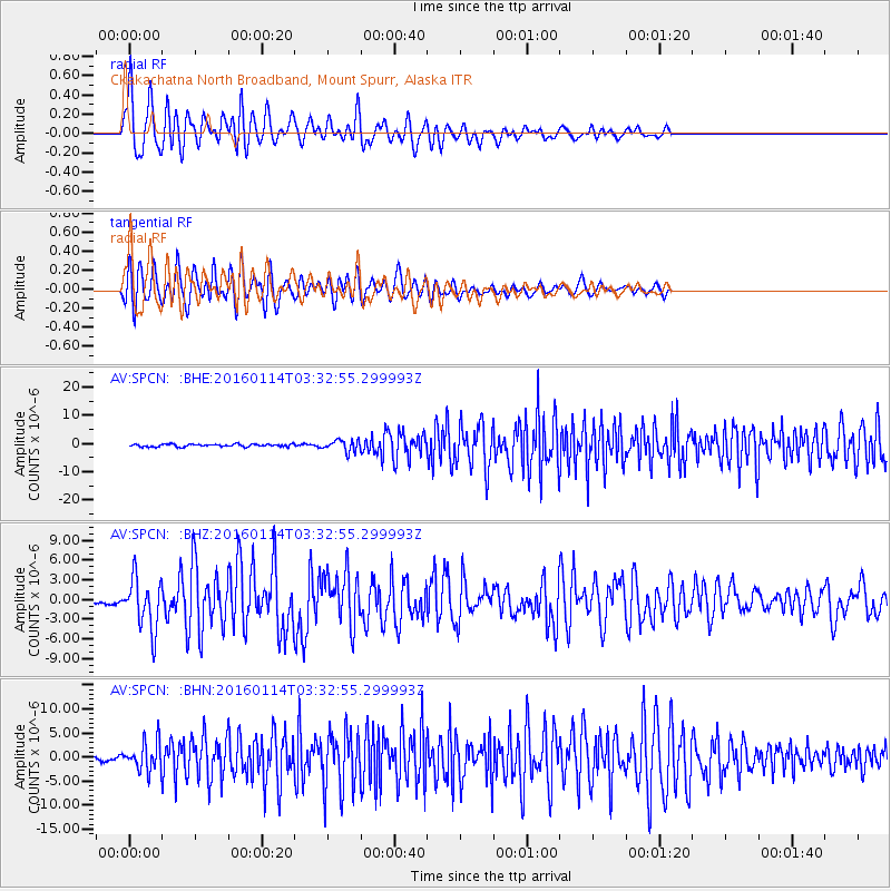
Signal To Noise
| Channel | StoN | STA | LTA |
| AV:SPCN: :BHZ:20160114T03:32:55.299993Z | 10.179206 | 3.9136594E-6 | 3.8447592E-7 |
| AV:SPCN: :BHN:20160114T03:32:55.299993Z | 4.3946276 | 3.081043E-6 | 7.010931E-7 |
| AV:SPCN: :BHE:20160114T03:32:55.299993Z | 4.78561 | 2.1566448E-6 | 4.5065195E-7 |
| Arrivals |
| Ps | 3.8 SECOND |
| PpPs | 13 SECOND |
| PsPs/PpSs | 17 SECOND |


