You are here: Home > Network List > AV - Alaska Volcano Observatory Stations List
> Station SPNN North Nagishlamina, Mount Spurr, Alaska > Earthquake Result Viewer
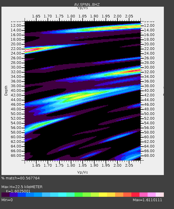
SPNN North Nagishlamina, Mount Spurr, Alaska - Earthquake Result Viewer
| Earthquake location: |
Hokkaido, Japan Region |
| Earthquake latitude/longitude: |
42.0/142.7 |
| Earthquake time(UTC): |
2016/01/14 (014) 03:25:34 GMT |
| Earthquake Depth: |
51 km |
| Earthquake Magnitude: |
6.7 MWP, 6.7 MI |
| Earthquake Catalog/Contributor: |
NEIC PDE/NEIC COMCAT |
|
| Network: |
AV Alaska Volcano Observatory |
| Station: |
SPNN North Nagishlamina, Mount Spurr, Alaska |
| Lat/Lon: |
61.37 N/152.70 W |
| Elevation: |
1666 m |
|
| Distance: |
42.4 deg |
| Az: |
40.136 deg |
| Baz: |
273.415 deg |
| Ray Param: |
0.073038265 |
| Estimated Moho Depth: |
22.5 km |
| Estimated Crust Vp/Vs: |
1.60 |
| Assumed Crust Vp: |
6.566 km/s |
| Estimated Crust Vs: |
4.097 km/s |
| Estimated Crust Poisson's Ratio: |
0.18 |
|
| Radial Match: |
80.567764 % |
| Radial Bump: |
400 |
| Transverse Match: |
73.763214 % |
| Transverse Bump: |
400 |
| SOD ConfigId: |
7422571 |
| Insert Time: |
2019-04-21 18:12:53.492 +0000 |
| GWidth: |
2.5 |
| Max Bumps: |
400 |
| Tol: |
0.001 |
|

Signal To Noise
| Channel | StoN | STA | LTA |
| AV:SPNN: :BHZ:20160114T03:32:53.199987Z | 4.9448686 | 1.9465062E-6 | 3.9364167E-7 |
| AV:SPNN: :BHN:20160114T03:32:53.199987Z | 2.0829618 | 5.492958E-7 | 2.63709E-7 |
| AV:SPNN: :BHE:20160114T03:32:53.199987Z | 5.4349747 | 1.2631513E-6 | 2.3241161E-7 |
| Arrivals |
| Ps | 2.2 SECOND |
| PpPs | 8.2 SECOND |
| PsPs/PpSs | 10 SECOND |


