You are here: Home > Network List > CH - Switzerland Seismological Network Stations List
> Station SENIN Lac Selin/Sanetsch > Earthquake Result Viewer
SENIN Lac Selin/Sanetsch - Earthquake Result Viewer

| Earthquake location: |
Hokkaido, Japan Region |
| Earthquake latitude/longitude: |
42.0/142.7 |
| Earthquake time(UTC): |
2016/01/14 (014) 03:25:34 GMT |
| Earthquake Depth: |
51 km |
| Earthquake Magnitude: |
6.7 MWP, 6.7 MI |
| Earthquake Catalog/Contributor: |
NEIC PDE/NEIC COMCAT |
|
| Network: |
CH Switzerland Seismological Network |
| Station: |
SENIN Lac Selin/Sanetsch |
| Lat/Lon: |
46.36 N/7.30 E |
| Elevation: |
2035 m |
|
| Distance: |
83.5 deg |
| Az: |
330.714 deg |
| Baz: |
31.797 deg |
| Ray Param: |
0.046025857 |
| Estimated Moho Depth: |
58.5 km |
| Estimated Crust Vp/Vs: |
1.63 |
| Assumed Crust Vp: |
6.276 km/s |
| Estimated Crust Vs: |
3.844 km/s |
| Estimated Crust Poisson's Ratio: |
0.20 |
|
| Radial Match: |
87.86847 % |
| Radial Bump: |
400 |
| Transverse Match: |
82.4647 % |
| Transverse Bump: |
400 |
| SOD ConfigId: |
7422571 |
| Insert Time: |
2019-04-21 18:13:41.243 +0000 |
| GWidth: |
2.5 |
| Max Bumps: |
400 |
| Tol: |
0.001 |
|
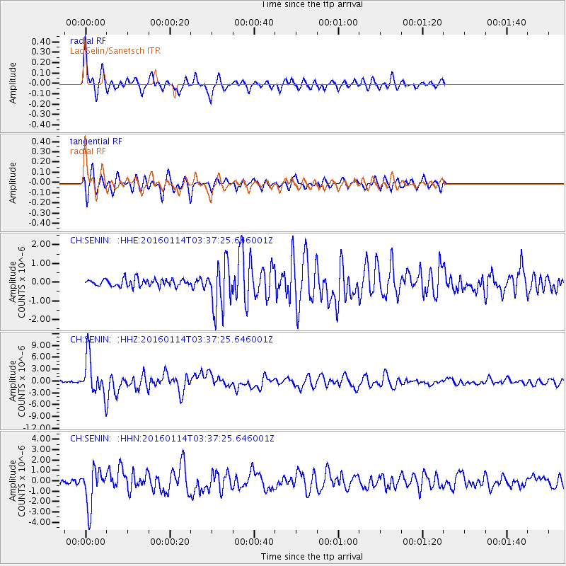
Signal To Noise
| Channel | StoN | STA | LTA |
| CH:SENIN: :HHZ:20160114T03:37:25.646001Z | 9.893496 | 4.90525E-6 | 4.958056E-7 |
| CH:SENIN: :HHN:20160114T03:37:25.646001Z | 7.0799747 | 1.838408E-6 | 2.596631E-7 |
| CH:SENIN: :HHE:20160114T03:37:25.646001Z | 6.6768284 | 1.2546067E-6 | 1.8790459E-7 |
| Arrivals |
| Ps | 6.1 SECOND |
| PpPs | 24 SECOND |
| PsPs/PpSs | 30 SECOND |


