You are here: Home > Network List > CI - Caltech Regional Seismic Network Stations List
> Station SMM Simmler, CA, USA > Earthquake Result Viewer
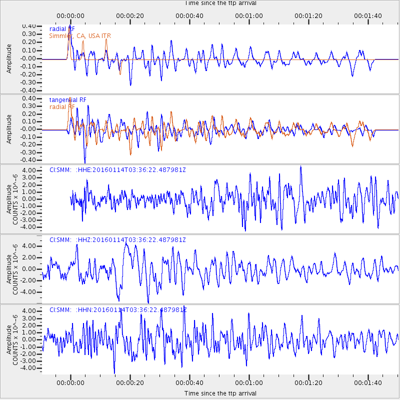
SMM Simmler, CA, USA - Earthquake Result Viewer
*The percent match for this event was below the threshold and hence no stack was calculated.
| Earthquake location: |
Hokkaido, Japan Region |
| Earthquake latitude/longitude: |
42.0/142.7 |
| Earthquake time(UTC): |
2016/01/14 (014) 03:25:34 GMT |
| Earthquake Depth: |
51 km |
| Earthquake Magnitude: |
6.7 MWP, 6.7 MI |
| Earthquake Catalog/Contributor: |
NEIC PDE/NEIC COMCAT |
|
| Network: |
CI Caltech Regional Seismic Network |
| Station: |
SMM Simmler, CA, USA |
| Lat/Lon: |
35.31 N/120.00 W |
| Elevation: |
599 m |
|
| Distance: |
72.2 deg |
| Az: |
58.438 deg |
| Baz: |
308.997 deg |
| Ray Param: |
$rayparam |
*The percent match for this event was below the threshold and hence was not used in the summary stack. |
|
| Radial Match: |
76.2745 % |
| Radial Bump: |
400 |
| Transverse Match: |
82.56715 % |
| Transverse Bump: |
400 |
| SOD ConfigId: |
7422571 |
| Insert Time: |
2019-04-21 18:14:23.632 +0000 |
| GWidth: |
2.5 |
| Max Bumps: |
400 |
| Tol: |
0.001 |
|
Signal To Noise
| Channel | StoN | STA | LTA |
| CI:SMM: :HHZ:20160114T03:36:22.487981Z | 2.3399923 | 1.8778354E-6 | 8.024964E-7 |
| CI:SMM: :HHN:20160114T03:36:22.487981Z | 0.94688725 | 1.2015313E-6 | 1.2689275E-6 |
| CI:SMM: :HHE:20160114T03:36:22.487981Z | 0.8774783 | 7.62385E-7 | 8.688363E-7 |
| Arrivals |
| Ps | |
| PpPs | |
| PsPs/PpSs | |


