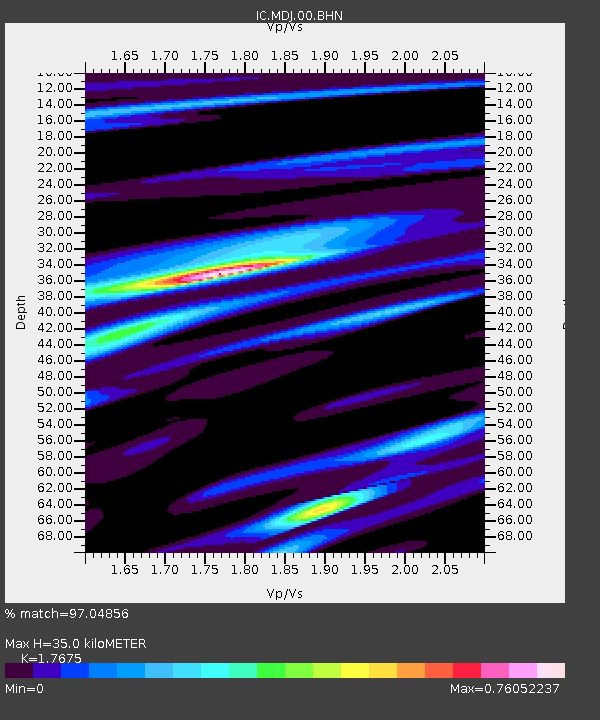
MDJ Mudanjiang, Heilongjiang Province, China - Earthquake Result Viewer

Earthquake location: Northern Sumatra, Indonesia
Earthquake latitude/longitude: 1.7/97.1
Earthquake time(UTC): 2006/07/27 (208) 11:16:40 GMT
Earthquake Depth: 20 km
Earthquake Magnitude: 5.6 MB, 6.1 MS, 6.1 MW, 6.0 MW
Earthquake Catalog/Contributor: WHDF/NEIC
Network: IC New China Digital Seismograph Network
Station: MDJ Mudanjiang, Heilongjiang Province, China
Lat/Lon: 44.62 N/129.59 E
Elevation: 250 m
Distance: 51.5 deg
Az: 29.334 deg
Baz: 223.288 deg
Ray Param: 0.06738041
Estimated Moho Depth: 35.0 km
Estimated Crust Vp/Vs: 1.77
Assumed Crust Vp: 6.459 km/s
Estimated Crust Vs: 3.655 km/s
Estimated Crust Poisson's Ratio: 0.26
Radial Match: 97.04856 %
Radial Bump: 201
Transverse Match: 83.94709 %
Transverse Bump: 400
SOD ConfigId: 2665
Insert Time: 2010-03-04 23:17:20.257 +0000
GWidth: 2.5
Max Bumps: 400
Tol: 0.001

Signal To Noise

ChannelStoNSTALTA
IC:MDJ:00:BHN:20060727T11:25:13.249028Z9.8311039.027067E-79.1821505E-8
IC:MDJ:00:BHE:20060727T11:25:13.249028Z8.8778391.0654694E-61.200145E-7
IC:MDJ:00:BHZ:20060727T11:25:13.249028Z22.7737392.4029735E-61.0551511E-7
Arrivals
Ps4.4 SECOND
PpPs14 SECOND
PsPs/PpSs19 SECOND