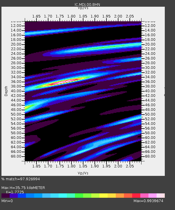
MDJ Mudanjiang, Heilongjiang Province, China - Earthquake Result Viewer
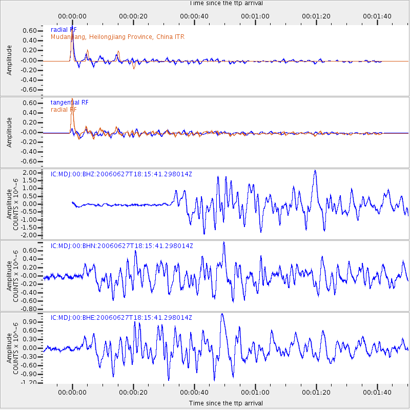
Earthquake location: Nicobar Islands, India Region
Earthquake latitude/longitude: 6.5/92.8
Earthquake time(UTC): 2006/06/27 (178) 18:07:22 GMT
Earthquake Depth: 29 km
Earthquake Magnitude: 5.8 MB, 6.1 MS, 6.2 MW, 5.9 MW
Earthquake Catalog/Contributor: WHDF/NEIC
Network: IC New China Digital Seismograph Network
Station: MDJ Mudanjiang, Heilongjiang Province, China
Lat/Lon: 44.62 N/129.59 E
Elevation: 250 m
Distance: 49.7 deg
Az: 34.128 deg
Baz: 231.314 deg
Ray Param: 0.06849241
Estimated Moho Depth: 35.75 km
Estimated Crust Vp/Vs: 1.77
Assumed Crust Vp: 6.459 km/s
Estimated Crust Vs: 3.644 km/s
Estimated Crust Poisson's Ratio: 0.27
Radial Match: 97.926994 %
Radial Bump: 257
Transverse Match: 91.7953 %
Transverse Bump: 400
SOD ConfigId: 2665
Insert Time: 2010-03-04 23:17:37.589 +0000
GWidth: 2.5
Max Bumps: 400
Tol: 0.001

Signal To Noise

ChannelStoNSTALTA
IC:MDJ:00:BHN:20060627T18:15:41.298014Z3.1151191.0467497E-73.360224E-8
IC:MDJ:00:BHE:20060627T18:15:41.298014Z3.97948621.562473E-73.926318E-8
IC:MDJ:00:BHZ:20060627T18:15:41.298014Z6.0705663.2749546E-75.3948092E-8
Arrivals
Ps4.5 SECOND
PpPs14 SECOND
PsPs/PpSs19 SECOND