You are here: Home > Network List > KZ - Kazakhstan Network Stations List
> Station OTUK ORTAU, Kazakstan > Earthquake Result Viewer
OTUK ORTAU, Kazakstan - Earthquake Result Viewer
| Earthquake location: |
Hokkaido, Japan Region |
| Earthquake latitude/longitude: |
42.0/142.7 |
| Earthquake time(UTC): |
2016/01/14 (014) 03:25:34 GMT |
| Earthquake Depth: |
51 km |
| Earthquake Magnitude: |
6.7 MWP, 6.7 MI |
| Earthquake Catalog/Contributor: |
NEIC PDE/NEIC COMCAT |
|
| Network: |
KZ Kazakhstan Network |
| Station: |
OTUK ORTAU, Kazakstan |
| Lat/Lon: |
48.24 N/72.34 E |
| Elevation: |
750 m |
|
| Distance: |
48.5 deg |
| Az: |
302.771 deg |
| Baz: |
69.77 deg |
| Ray Param: |
0.06918855 |
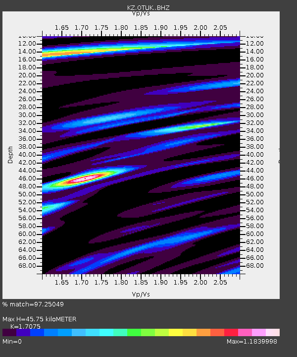
| Estimated Moho Depth: |
45.75 km |
| Estimated Crust Vp/Vs: |
1.71 |
| Assumed Crust Vp: |
6.571 km/s |
| Estimated Crust Vs: |
3.848 km/s |
| Estimated Crust Poisson's Ratio: |
0.24 |
|
| Radial Match: |
97.25049 % |
| Radial Bump: |
317 |
| Transverse Match: |
88.57679 % |
| Transverse Bump: |
400 |
| SOD ConfigId: |
7422571 |
| Insert Time: |
2019-04-21 18:17:18.561 +0000 |
| GWidth: |
2.5 |
| Max Bumps: |
400 |
| Tol: |
0.001 |
|

Signal To Noise
| Channel | StoN | STA | LTA |
| KZ:OTUK: :BHZ:20160114T03:33:36.651006Z | 194.43208 | 1.1230991E-5 | 5.7763053E-8 |
| KZ:OTUK: :BHN:20160114T03:33:36.651006Z | 44.29748 | 2.2243896E-6 | 5.0214805E-8 |
| KZ:OTUK: :BHE:20160114T03:33:36.651006Z | 132.03456 | 5.2674072E-6 | 3.9894154E-8 |
| Arrivals |
| Ps | 5.3 SECOND |
| PpPs | 18 SECOND |
| PsPs/PpSs | 23 SECOND |


