You are here: Home > Network List > ND - New CaleDonia Broadband Seismic Network Stations List
> Station KOUNC Koumac, New Caledonia > Earthquake Result Viewer
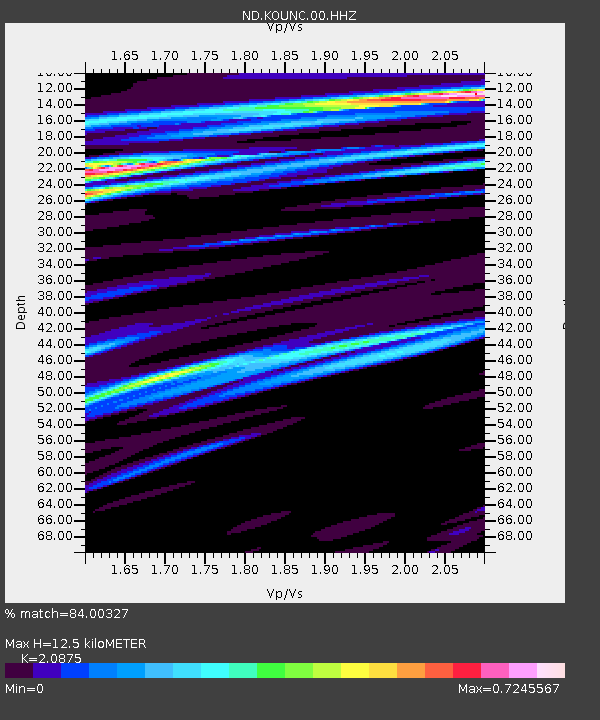
KOUNC Koumac, New Caledonia - Earthquake Result Viewer
| Earthquake location: |
Hokkaido, Japan Region |
| Earthquake latitude/longitude: |
42.0/142.7 |
| Earthquake time(UTC): |
2016/01/14 (014) 03:25:34 GMT |
| Earthquake Depth: |
51 km |
| Earthquake Magnitude: |
6.7 MWP, 6.7 MI |
| Earthquake Catalog/Contributor: |
NEIC PDE/NEIC COMCAT |
|
| Network: |
ND New CaleDonia Broadband Seismic Network |
| Station: |
KOUNC Koumac, New Caledonia |
| Lat/Lon: |
20.55 S/164.29 E |
| Elevation: |
88 m |
|
| Distance: |
65.3 deg |
| Az: |
157.721 deg |
| Baz: |
342.436 deg |
| Ray Param: |
0.058244772 |
| Estimated Moho Depth: |
12.5 km |
| Estimated Crust Vp/Vs: |
2.09 |
| Assumed Crust Vp: |
5.14 km/s |
| Estimated Crust Vs: |
2.462 km/s |
| Estimated Crust Poisson's Ratio: |
0.35 |
|
| Radial Match: |
84.00327 % |
| Radial Bump: |
400 |
| Transverse Match: |
83.883896 % |
| Transverse Bump: |
400 |
| SOD ConfigId: |
7422571 |
| Insert Time: |
2019-04-21 18:19:58.080 +0000 |
| GWidth: |
2.5 |
| Max Bumps: |
400 |
| Tol: |
0.001 |
|

Signal To Noise
| Channel | StoN | STA | LTA |
| ND:KOUNC:00:HHZ:20160114T03:35:40.140996Z | 4.132392 | 8.6021225E-7 | 2.0816329E-7 |
| ND:KOUNC:00:HHN:20160114T03:35:40.140996Z | 1.4762126 | 2.1837165E-7 | 1.4792697E-7 |
| ND:KOUNC:00:HHE:20160114T03:35:40.140996Z | 1.9730487 | 2.8406487E-7 | 1.4397257E-7 |
| Arrivals |
| Ps | 2.7 SECOND |
| PpPs | 7.3 SECOND |
| PsPs/PpSs | 10 SECOND |


