You are here: Home > Network List > NY - Yukon Northwest Seismic Network(YNSN) Stations List
> Station WTLY Watson Lake, Yukon, CANADA > Earthquake Result Viewer
WTLY Watson Lake, Yukon, CANADA - Earthquake Result Viewer
| Earthquake location: |
Hokkaido, Japan Region |
| Earthquake latitude/longitude: |
42.0/142.7 |
| Earthquake time(UTC): |
2016/01/14 (014) 03:25:34 GMT |
| Earthquake Depth: |
51 km |
| Earthquake Magnitude: |
6.7 MWP, 6.7 MI |
| Earthquake Catalog/Contributor: |
NEIC PDE/NEIC COMCAT |
|
| Network: |
NY Yukon Northwest Seismic Network(YNSN) |
| Station: |
WTLY Watson Lake, Yukon, CANADA |
| Lat/Lon: |
60.11 N/128.80 W |
| Elevation: |
0.0 m |
|
| Distance: |
54.1 deg |
| Az: |
38.172 deg |
| Baz: |
292.996 deg |
| Ray Param: |
0.065537475 |
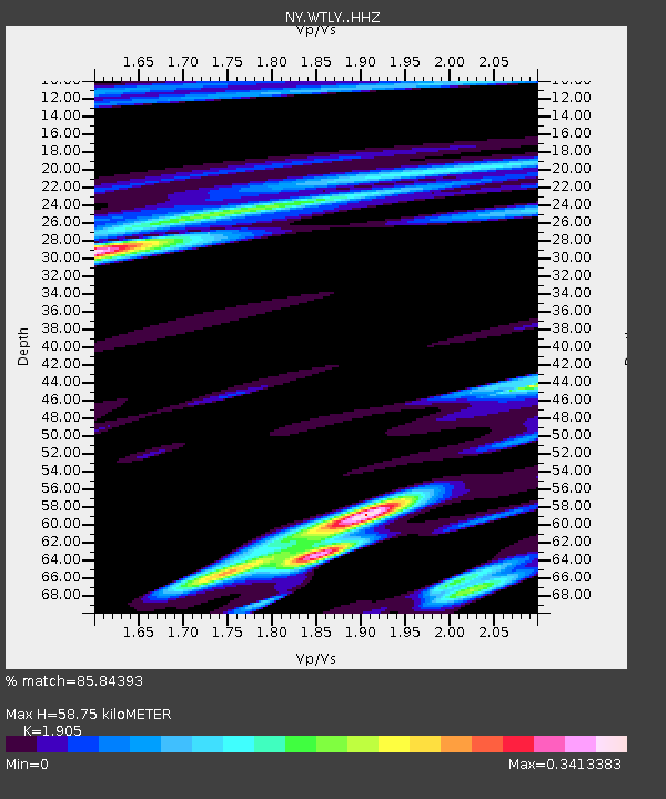
| Estimated Moho Depth: |
58.75 km |
| Estimated Crust Vp/Vs: |
1.90 |
| Assumed Crust Vp: |
6.35 km/s |
| Estimated Crust Vs: |
3.333 km/s |
| Estimated Crust Poisson's Ratio: |
0.31 |
|
| Radial Match: |
85.84393 % |
| Radial Bump: |
239 |
| Transverse Match: |
61.027237 % |
| Transverse Bump: |
400 |
| SOD ConfigId: |
7422571 |
| Insert Time: |
2019-04-21 18:20:55.091 +0000 |
| GWidth: |
2.5 |
| Max Bumps: |
400 |
| Tol: |
0.001 |
|

Signal To Noise
| Channel | StoN | STA | LTA |
| NY:WTLY: :HHZ:20160114T03:34:22.89002Z | 5.7874327 | 1.4163433E-6 | 2.4472737E-7 |
| NY:WTLY: :HHN:20160114T03:34:22.89002Z | 1.8679972 | 5.589782E-7 | 2.9923933E-7 |
| NY:WTLY: :HHE:20160114T03:34:22.89002Z | 5.575702 | 1.5709495E-6 | 2.8174918E-7 |
| Arrivals |
| Ps | 8.8 SECOND |
| PpPs | 26 SECOND |
| PsPs/PpSs | 34 SECOND |


