You are here: Home > Network List > OX - North-East Italy Seismic Network Stations List
> Station DRE Drenchia > Earthquake Result Viewer
DRE Drenchia - Earthquake Result Viewer
| Earthquake location: |
Hokkaido, Japan Region |
| Earthquake latitude/longitude: |
42.0/142.7 |
| Earthquake time(UTC): |
2016/01/14 (014) 03:25:34 GMT |
| Earthquake Depth: |
51 km |
| Earthquake Magnitude: |
6.7 MWP, 6.7 MI |
| Earthquake Catalog/Contributor: |
NEIC PDE/NEIC COMCAT |
|
| Network: |
OX North-East Italy Seismic Network |
| Station: |
DRE Drenchia |
| Lat/Lon: |
46.17 N/13.65 E |
| Elevation: |
810 m |
|
| Distance: |
81.2 deg |
| Az: |
326.919 deg |
| Baz: |
35.867 deg |
| Ray Param: |
0.047629036 |
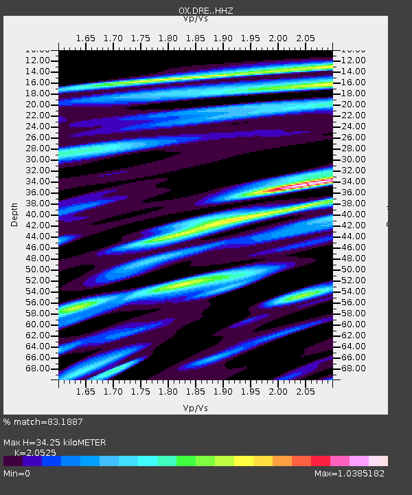
| Estimated Moho Depth: |
34.25 km |
| Estimated Crust Vp/Vs: |
2.05 |
| Assumed Crust Vp: |
6.35 km/s |
| Estimated Crust Vs: |
3.094 km/s |
| Estimated Crust Poisson's Ratio: |
0.34 |
|
| Radial Match: |
83.1887 % |
| Radial Bump: |
400 |
| Transverse Match: |
61.476177 % |
| Transverse Bump: |
400 |
| SOD ConfigId: |
7422571 |
| Insert Time: |
2019-04-21 18:21:11.515 +0000 |
| GWidth: |
2.5 |
| Max Bumps: |
400 |
| Tol: |
0.001 |
|

Signal To Noise
| Channel | StoN | STA | LTA |
| OX:DRE: :HHZ:20160114T03:37:13.747991Z | 28.670675 | 3.702703E-6 | 1.29146E-7 |
| OX:DRE: :HHN:20160114T03:37:13.747991Z | 12.350251 | 1.2659414E-6 | 1.0250329E-7 |
| OX:DRE: :HHE:20160114T03:37:13.747991Z | 6.306975 | 8.341629E-7 | 1.3226038E-7 |
| Arrivals |
| Ps | 5.8 SECOND |
| PpPs | 16 SECOND |
| PsPs/PpSs | 22 SECOND |


