You are here: Home > Network List > S - Seismographs in Schools Projects Stations List
> Station AUDHS Darwin Hight School, NT > Earthquake Result Viewer
AUDHS Darwin Hight School, NT - Earthquake Result Viewer
| Earthquake location: |
Hokkaido, Japan Region |
| Earthquake latitude/longitude: |
42.0/142.7 |
| Earthquake time(UTC): |
2016/01/14 (014) 03:25:34 GMT |
| Earthquake Depth: |
51 km |
| Earthquake Magnitude: |
6.7 MWP, 6.7 MI |
| Earthquake Catalog/Contributor: |
NEIC PDE/NEIC COMCAT |
|
| Network: |
S Seismographs in Schools Projects |
| Station: |
AUDHS Darwin Hight School, NT |
| Lat/Lon: |
12.44 S/130.83 E |
| Elevation: |
60 m |
|
| Distance: |
55.2 deg |
| Az: |
194.181 deg |
| Baz: |
10.783 deg |
| Ray Param: |
0.064812176 |
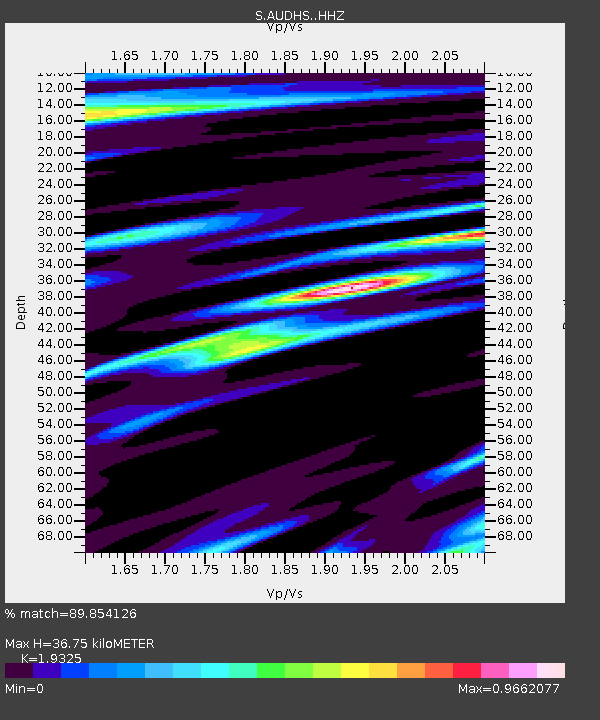
| Estimated Moho Depth: |
36.75 km |
| Estimated Crust Vp/Vs: |
1.93 |
| Assumed Crust Vp: |
6.61 km/s |
| Estimated Crust Vs: |
3.42 km/s |
| Estimated Crust Poisson's Ratio: |
0.32 |
|
| Radial Match: |
89.854126 % |
| Radial Bump: |
400 |
| Transverse Match: |
80.73485 % |
| Transverse Bump: |
400 |
| SOD ConfigId: |
7422571 |
| Insert Time: |
2019-04-21 18:21:48.951 +0000 |
| GWidth: |
2.5 |
| Max Bumps: |
400 |
| Tol: |
0.001 |
|

Signal To Noise
| Channel | StoN | STA | LTA |
| S:AUDHS: :HHZ:20160114T03:34:31.500005Z | 8.157927 | 2.035939E-6 | 2.4956574E-7 |
| S:AUDHS: :HHN:20160114T03:34:31.500005Z | 4.758531 | 1.0963628E-6 | 2.3039942E-7 |
| S:AUDHS: :HHE:20160114T03:34:31.500005Z | 1.946154 | 6.5059305E-7 | 3.342968E-7 |
| Arrivals |
| Ps | 5.5 SECOND |
| PpPs | 16 SECOND |
| PsPs/PpSs | 21 SECOND |


