You are here: Home > Network List > TA - USArray Transportable Network (new EarthScope stations) Stations List
> Station J05D Fort Rock, OR, USA > Earthquake Result Viewer
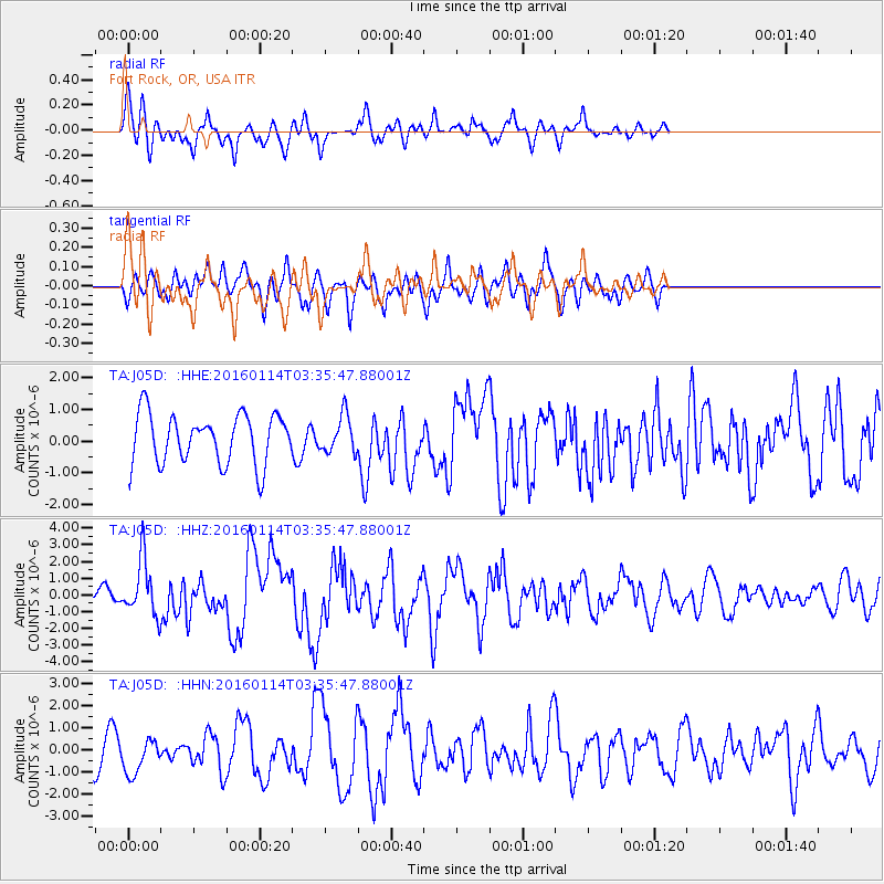
J05D Fort Rock, OR, USA - Earthquake Result Viewer
*The percent match for this event was below the threshold and hence no stack was calculated.
| Earthquake location: |
Hokkaido, Japan Region |
| Earthquake latitude/longitude: |
42.0/142.7 |
| Earthquake time(UTC): |
2016/01/14 (014) 03:25:34 GMT |
| Earthquake Depth: |
51 km |
| Earthquake Magnitude: |
6.7 MWP, 6.7 MI |
| Earthquake Catalog/Contributor: |
NEIC PDE/NEIC COMCAT |
|
| Network: |
TA USArray Transportable Network (new EarthScope stations) |
| Station: |
J05D Fort Rock, OR, USA |
| Lat/Lon: |
43.28 N/121.23 W |
| Elevation: |
1541 m |
|
| Distance: |
66.6 deg |
| Az: |
52.322 deg |
| Baz: |
306.055 deg |
| Ray Param: |
$rayparam |
*The percent match for this event was below the threshold and hence was not used in the summary stack. |
|
| Radial Match: |
69.88915 % |
| Radial Bump: |
400 |
| Transverse Match: |
43.421852 % |
| Transverse Bump: |
360 |
| SOD ConfigId: |
7422571 |
| Insert Time: |
2019-04-21 18:22:38.257 +0000 |
| GWidth: |
2.5 |
| Max Bumps: |
400 |
| Tol: |
0.001 |
|
Signal To Noise
| Channel | StoN | STA | LTA |
| TA:J05D: :HHZ:20160114T03:35:47.88001Z | 2.4670374 | 1.7001146E-6 | 6.8913204E-7 |
| TA:J05D: :HHN:20160114T03:35:47.88001Z | 0.73096395 | 7.8173514E-7 | 1.0694579E-6 |
| TA:J05D: :HHE:20160114T03:35:47.88001Z | 0.79552704 | 6.062332E-7 | 7.620522E-7 |
| Arrivals |
| Ps | |
| PpPs | |
| PsPs/PpSs | |


