You are here: Home > Network List > TA - USArray Transportable Network (new EarthScope stations) Stations List
> Station K22A Casper, WY, USA > Earthquake Result Viewer
K22A Casper, WY, USA - Earthquake Result Viewer

| Earthquake location: |
Hokkaido, Japan Region |
| Earthquake latitude/longitude: |
42.0/142.7 |
| Earthquake time(UTC): |
2016/01/14 (014) 03:25:34 GMT |
| Earthquake Depth: |
51 km |
| Earthquake Magnitude: |
6.7 MWP, 6.7 MI |
| Earthquake Catalog/Contributor: |
NEIC PDE/NEIC COMCAT |
|
| Network: |
TA USArray Transportable Network (new EarthScope stations) |
| Station: |
K22A Casper, WY, USA |
| Lat/Lon: |
42.65 N/106.52 W |
| Elevation: |
1686 m |
|
| Distance: |
75.3 deg |
| Az: |
45.511 deg |
| Baz: |
313.839 deg |
| Ray Param: |
0.051697146 |
| Estimated Moho Depth: |
20.5 km |
| Estimated Crust Vp/Vs: |
1.76 |
| Assumed Crust Vp: |
6.178 km/s |
| Estimated Crust Vs: |
3.51 km/s |
| Estimated Crust Poisson's Ratio: |
0.26 |
|
| Radial Match: |
87.404335 % |
| Radial Bump: |
340 |
| Transverse Match: |
70.77743 % |
| Transverse Bump: |
400 |
| SOD ConfigId: |
7422571 |
| Insert Time: |
2019-04-21 18:22:44.178 +0000 |
| GWidth: |
2.5 |
| Max Bumps: |
400 |
| Tol: |
0.001 |
|
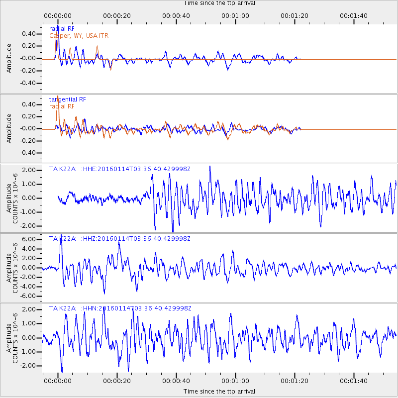
Signal To Noise
| Channel | StoN | STA | LTA |
| TA:K22A: :HHZ:20160114T03:36:40.429998Z | 14.268644 | 2.5769277E-6 | 1.8060074E-7 |
| TA:K22A: :HHN:20160114T03:36:40.429998Z | 3.782082 | 1.0375359E-6 | 2.743293E-7 |
| TA:K22A: :HHE:20160114T03:36:40.429998Z | 4.6341004 | 9.08059E-7 | 1.9595153E-7 |
| Arrivals |
| Ps | 2.6 SECOND |
| PpPs | 8.9 SECOND |
| PsPs/PpSs | 11 SECOND |


