You are here: Home > Network List > TA - USArray Transportable Network (new EarthScope stations) Stations List
> Station M26K Nabesna, AK, USA > Earthquake Result Viewer
M26K Nabesna, AK, USA - Earthquake Result Viewer
| Earthquake location: |
Hokkaido, Japan Region |
| Earthquake latitude/longitude: |
42.0/142.7 |
| Earthquake time(UTC): |
2016/01/14 (014) 03:25:34 GMT |
| Earthquake Depth: |
51 km |
| Earthquake Magnitude: |
6.7 MWP, 6.7 MI |
| Earthquake Catalog/Contributor: |
NEIC PDE/NEIC COMCAT |
|
| Network: |
TA USArray Transportable Network (new EarthScope stations) |
| Station: |
M26K Nabesna, AK, USA |
| Lat/Lon: |
62.40 N/143.00 W |
| Elevation: |
888 m |
|
| Distance: |
46.9 deg |
| Az: |
37.891 deg |
| Baz: |
280.368 deg |
| Ray Param: |
0.07021754 |
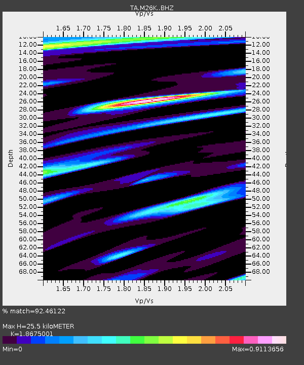
| Estimated Moho Depth: |
25.5 km |
| Estimated Crust Vp/Vs: |
1.87 |
| Assumed Crust Vp: |
6.566 km/s |
| Estimated Crust Vs: |
3.516 km/s |
| Estimated Crust Poisson's Ratio: |
0.30 |
|
| Radial Match: |
92.46122 % |
| Radial Bump: |
381 |
| Transverse Match: |
70.751 % |
| Transverse Bump: |
400 |
| SOD ConfigId: |
7422571 |
| Insert Time: |
2019-04-21 18:22:53.996 +0000 |
| GWidth: |
2.5 |
| Max Bumps: |
400 |
| Tol: |
0.001 |
|

Signal To Noise
| Channel | StoN | STA | LTA |
| TA:M26K: :BHZ:20160114T03:33:28.524999Z | 8.426186 | 2.8364962E-6 | 3.3662872E-7 |
| TA:M26K: :BHN:20160114T03:33:28.524999Z | 2.9585009 | 5.895103E-7 | 1.992598E-7 |
| TA:M26K: :BHE:20160114T03:33:28.524999Z | 8.215635 | 1.4135497E-6 | 1.7205605E-7 |
| Arrivals |
| Ps | 3.6 SECOND |
| PpPs | 10 SECOND |
| PsPs/PpSs | 14 SECOND |


