You are here: Home > Network List > TA - USArray Transportable Network (new EarthScope stations) Stations List
> Station Q24A Divide, CO, USA > Earthquake Result Viewer
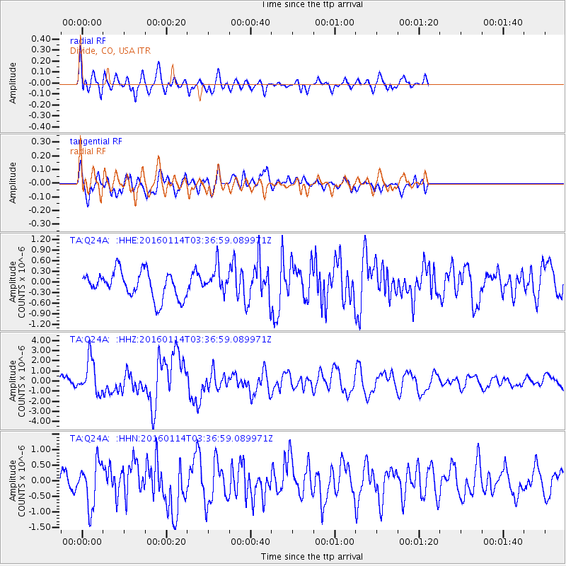
Q24A Divide, CO, USA - Earthquake Result Viewer
*The percent match for this event was below the threshold and hence no stack was calculated.
| Earthquake location: |
Hokkaido, Japan Region |
| Earthquake latitude/longitude: |
42.0/142.7 |
| Earthquake time(UTC): |
2016/01/14 (014) 03:25:34 GMT |
| Earthquake Depth: |
51 km |
| Earthquake Magnitude: |
6.7 MWP, 6.7 MI |
| Earthquake Catalog/Contributor: |
NEIC PDE/NEIC COMCAT |
|
| Network: |
TA USArray Transportable Network (new EarthScope stations) |
| Station: |
Q24A Divide, CO, USA |
| Lat/Lon: |
38.96 N/105.15 W |
| Elevation: |
2775 m |
|
| Distance: |
78.6 deg |
| Az: |
47.456 deg |
| Baz: |
315.175 deg |
| Ray Param: |
$rayparam |
*The percent match for this event was below the threshold and hence was not used in the summary stack. |
|
| Radial Match: |
64.22136 % |
| Radial Bump: |
400 |
| Transverse Match: |
61.186546 % |
| Transverse Bump: |
400 |
| SOD ConfigId: |
7422571 |
| Insert Time: |
2019-04-21 18:23:13.977 +0000 |
| GWidth: |
2.5 |
| Max Bumps: |
400 |
| Tol: |
0.001 |
|
Signal To Noise
| Channel | StoN | STA | LTA |
| TA:Q24A: :HHZ:20160114T03:36:59.089971Z | 3.7583854 | 1.7267699E-6 | 4.594446E-7 |
| TA:Q24A: :HHN:20160114T03:36:59.089971Z | 2.0355864 | 7.215407E-7 | 3.5446334E-7 |
| TA:Q24A: :HHE:20160114T03:36:59.089971Z | 1.0698653 | 3.9861928E-7 | 3.7258826E-7 |
| Arrivals |
| Ps | |
| PpPs | |
| PsPs/PpSs | |


