You are here: Home > Network List > TM - Thai Seismic Monitoring Network Stations List
> Station MHIT MHIT Phase1 > Earthquake Result Viewer
MHIT MHIT Phase1 - Earthquake Result Viewer
| Earthquake location: |
Hokkaido, Japan Region |
| Earthquake latitude/longitude: |
42.0/142.7 |
| Earthquake time(UTC): |
2016/01/14 (014) 03:25:34 GMT |
| Earthquake Depth: |
51 km |
| Earthquake Magnitude: |
6.7 MWP, 6.7 MI |
| Earthquake Catalog/Contributor: |
NEIC PDE/NEIC COMCAT |
|
| Network: |
TM Thai Seismic Monitoring Network |
| Station: |
MHIT MHIT Phase1 |
| Lat/Lon: |
19.31 N/97.96 E |
| Elevation: |
270 m |
|
| Distance: |
44.0 deg |
| Az: |
253.15 deg |
| Baz: |
49.107 deg |
| Ray Param: |
0.07204409 |
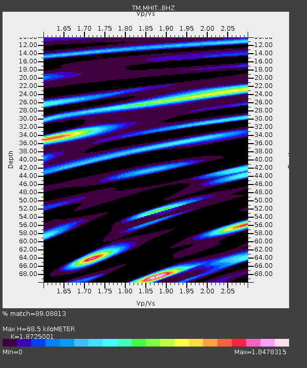
| Estimated Moho Depth: |
68.5 km |
| Estimated Crust Vp/Vs: |
1.87 |
| Assumed Crust Vp: |
6.316 km/s |
| Estimated Crust Vs: |
3.373 km/s |
| Estimated Crust Poisson's Ratio: |
0.30 |
|
| Radial Match: |
89.08813 % |
| Radial Bump: |
400 |
| Transverse Match: |
97.64533 % |
| Transverse Bump: |
215 |
| SOD ConfigId: |
7422571 |
| Insert Time: |
2019-04-21 18:23:43.388 +0000 |
| GWidth: |
2.5 |
| Max Bumps: |
400 |
| Tol: |
0.001 |
|

Signal To Noise
| Channel | StoN | STA | LTA |
| TM:MHIT: :BHZ:20160114T03:33:06.549993Z | 29.425077 | 6.353835E-6 | 2.1593266E-7 |
| TM:MHIT: :BHN:20160114T03:33:06.549993Z | 50.58573 | 5.6140816E-6 | 1.10981524E-7 |
| TM:MHIT: :BHE:20160114T03:33:06.549993Z | 7.3483 | 1.5792999E-6 | 2.1492046E-7 |
| Arrivals |
| Ps | 10 SECOND |
| PpPs | 29 SECOND |
| PsPs/PpSs | 39 SECOND |


