You are here: Home > Network List > UW - Pacific Northwest Regional Seismic Network Stations List
> Station LEBA Lebam, WA, USA > Earthquake Result Viewer
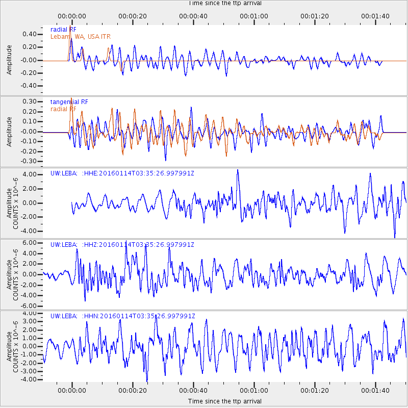
LEBA Lebam, WA, USA - Earthquake Result Viewer
*The percent match for this event was below the threshold and hence no stack was calculated.
| Earthquake location: |
Hokkaido, Japan Region |
| Earthquake latitude/longitude: |
42.0/142.7 |
| Earthquake time(UTC): |
2016/01/14 (014) 03:25:34 GMT |
| Earthquake Depth: |
51 km |
| Earthquake Magnitude: |
6.7 MWP, 6.7 MI |
| Earthquake Catalog/Contributor: |
NEIC PDE/NEIC COMCAT |
|
| Network: |
UW Pacific Northwest Regional Seismic Network |
| Station: |
LEBA Lebam, WA, USA |
| Lat/Lon: |
46.55 N/123.56 W |
| Elevation: |
73 m |
|
| Distance: |
63.3 deg |
| Az: |
50.411 deg |
| Baz: |
303.606 deg |
| Ray Param: |
$rayparam |
*The percent match for this event was below the threshold and hence was not used in the summary stack. |
|
| Radial Match: |
59.451115 % |
| Radial Bump: |
400 |
| Transverse Match: |
60.756233 % |
| Transverse Bump: |
400 |
| SOD ConfigId: |
7422571 |
| Insert Time: |
2019-04-21 18:24:13.233 +0000 |
| GWidth: |
2.5 |
| Max Bumps: |
400 |
| Tol: |
0.001 |
|
Signal To Noise
| Channel | StoN | STA | LTA |
| UW:LEBA: :HHZ:20160114T03:35:26.997991Z | 5.474615 | 2.2564839E-6 | 4.1217214E-7 |
| UW:LEBA: :HHN:20160114T03:35:26.997991Z | 0.98594296 | 1.0517173E-6 | 1.0667121E-6 |
| UW:LEBA: :HHE:20160114T03:35:26.997991Z | 1.7655002 | 1.2205157E-6 | 6.913144E-7 |
| Arrivals |
| Ps | |
| PpPs | |
| PsPs/PpSs | |


