You are here: Home > Network List > XQ15 - Rapid response to the Mw 7.9 earthquake of April 25, 2015 in Nepal Stations List
> Station NA030 Katmandu,Nepal > Earthquake Result Viewer
NA030 Katmandu,Nepal - Earthquake Result Viewer
| Earthquake location: |
Hokkaido, Japan Region |
| Earthquake latitude/longitude: |
42.0/142.7 |
| Earthquake time(UTC): |
2016/01/14 (014) 03:25:34 GMT |
| Earthquake Depth: |
51 km |
| Earthquake Magnitude: |
6.7 MWP, 6.7 MI |
| Earthquake Catalog/Contributor: |
NEIC PDE/NEIC COMCAT |
|
| Network: |
XQ Rapid response to the Mw 7.9 earthquake of April 25, 2015 in Nepal |
| Station: |
NA030 Katmandu,Nepal |
| Lat/Lon: |
28.12 N/84.64 E |
| Elevation: |
861 m |
|
| Distance: |
48.7 deg |
| Az: |
272.948 deg |
| Baz: |
57.497 deg |
| Ray Param: |
0.069080226 |
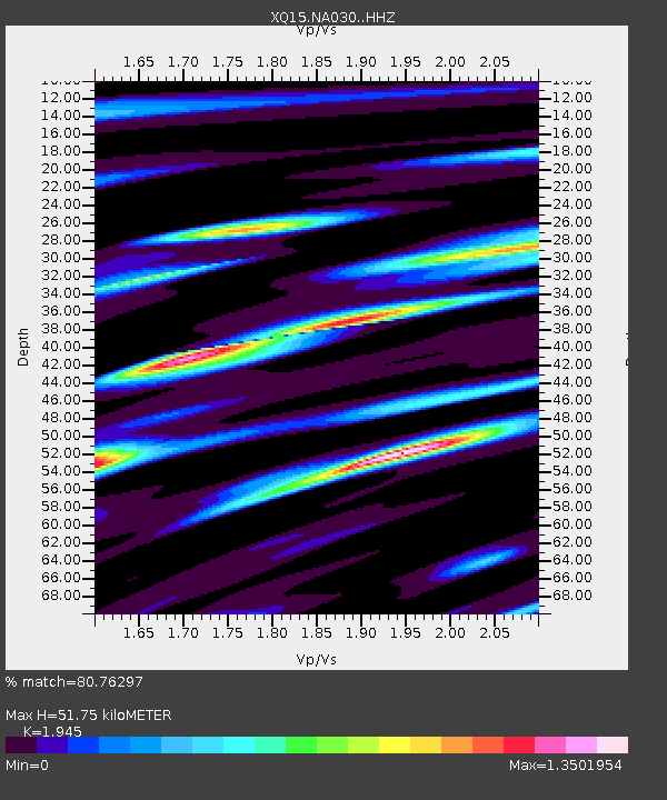
| Estimated Moho Depth: |
51.75 km |
| Estimated Crust Vp/Vs: |
1.95 |
| Assumed Crust Vp: |
6.481 km/s |
| Estimated Crust Vs: |
3.332 km/s |
| Estimated Crust Poisson's Ratio: |
0.32 |
|
| Radial Match: |
80.76297 % |
| Radial Bump: |
400 |
| Transverse Match: |
70.95659 % |
| Transverse Bump: |
400 |
| SOD ConfigId: |
7422571 |
| Insert Time: |
2019-04-21 18:25:55.182 +0000 |
| GWidth: |
2.5 |
| Max Bumps: |
400 |
| Tol: |
0.001 |
|

Signal To Noise
| Channel | StoN | STA | LTA |
| XQ:NA030: :HHZ:20160114T03:33:42.850011Z | 138.4893 | 7.0675296E-6 | 5.1033037E-8 |
| XQ:NA030: :HH1:20160114T03:33:42.850011Z | 65.3133 | 2.803621E-6 | 4.2925727E-8 |
| XQ:NA030: :HH2:20160114T03:33:42.850011Z | 42.640472 | 3.4413135E-6 | 8.0705334E-8 |
| Arrivals |
| Ps | 8.0 SECOND |
| PpPs | 22 SECOND |
| PsPs/PpSs | 30 SECOND |


