You are here: Home > Network List > XQ15 - Rapid response to the Mw 7.9 earthquake of April 25, 2015 in Nepal Stations List
> Station NA300 Katmandu,Nepal > Earthquake Result Viewer
NA300 Katmandu,Nepal - Earthquake Result Viewer
| Earthquake location: |
Hokkaido, Japan Region |
| Earthquake latitude/longitude: |
42.0/142.7 |
| Earthquake time(UTC): |
2016/01/14 (014) 03:25:34 GMT |
| Earthquake Depth: |
51 km |
| Earthquake Magnitude: |
6.7 MWP, 6.7 MI |
| Earthquake Catalog/Contributor: |
NEIC PDE/NEIC COMCAT |
|
| Network: |
XQ Rapid response to the Mw 7.9 earthquake of April 25, 2015 in Nepal |
| Station: |
NA300 Katmandu,Nepal |
| Lat/Lon: |
27.49 N/86.09 E |
| Elevation: |
897 m |
|
| Distance: |
47.9 deg |
| Az: |
271.318 deg |
| Baz: |
57.084 deg |
| Ray Param: |
0.069562346 |
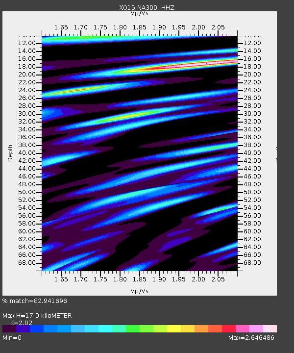
| Estimated Moho Depth: |
17.0 km |
| Estimated Crust Vp/Vs: |
2.02 |
| Assumed Crust Vp: |
6.236 km/s |
| Estimated Crust Vs: |
3.087 km/s |
| Estimated Crust Poisson's Ratio: |
0.34 |
|
| Radial Match: |
82.941696 % |
| Radial Bump: |
400 |
| Transverse Match: |
79.790955 % |
| Transverse Bump: |
400 |
| SOD ConfigId: |
7422571 |
| Insert Time: |
2019-04-21 18:26:05.526 +0000 |
| GWidth: |
2.5 |
| Max Bumps: |
400 |
| Tol: |
0.001 |
|

Signal To Noise
| Channel | StoN | STA | LTA |
| XQ:NA300: :HHZ:20160114T03:33:37.139989Z | 156.19052 | 7.425331E-6 | 4.7540215E-8 |
| XQ:NA300: :HH1:20160114T03:33:37.139989Z | 12.824869 | 2.4815058E-6 | 1.934917E-7 |
| XQ:NA300: :HH2:20160114T03:33:37.139989Z | 22.62606 | 3.0466329E-6 | 1.346515E-7 |
| Arrivals |
| Ps | 2.9 SECOND |
| PpPs | 7.8 SECOND |
| PsPs/PpSs | 11 SECOND |


