You are here: Home > Network List > YN10 - San Jacinto Fault Zone Stations List
> Station RHIL RHIL > Earthquake Result Viewer
RHIL RHIL - Earthquake Result Viewer
| Earthquake location: |
Hokkaido, Japan Region |
| Earthquake latitude/longitude: |
42.0/142.7 |
| Earthquake time(UTC): |
2016/01/14 (014) 03:25:34 GMT |
| Earthquake Depth: |
51 km |
| Earthquake Magnitude: |
6.7 MWP, 6.7 MI |
| Earthquake Catalog/Contributor: |
NEIC PDE/NEIC COMCAT |
|
| Network: |
YN San Jacinto Fault Zone |
| Station: |
RHIL RHIL |
| Lat/Lon: |
33.67 N/116.77 W |
| Elevation: |
1557 m |
|
| Distance: |
75.3 deg |
| Az: |
57.97 deg |
| Baz: |
310.684 deg |
| Ray Param: |
0.05167842 |
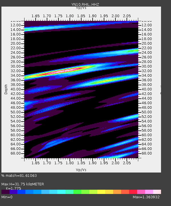
| Estimated Moho Depth: |
31.75 km |
| Estimated Crust Vp/Vs: |
1.77 |
| Assumed Crust Vp: |
6.264 km/s |
| Estimated Crust Vs: |
3.529 km/s |
| Estimated Crust Poisson's Ratio: |
0.27 |
|
| Radial Match: |
81.61063 % |
| Radial Bump: |
400 |
| Transverse Match: |
74.51305 % |
| Transverse Bump: |
400 |
| SOD ConfigId: |
7422571 |
| Insert Time: |
2019-04-21 18:26:33.214 +0000 |
| GWidth: |
2.5 |
| Max Bumps: |
400 |
| Tol: |
0.001 |
|

Signal To Noise
| Channel | StoN | STA | LTA |
| YN:RHIL: :HHZ:20160114T03:36:40.573979Z | 3.000882 | 1.2172466E-6 | 4.056296E-7 |
| YN:RHIL: :HHN:20160114T03:36:40.573979Z | 2.04172 | 5.208223E-7 | 2.5509E-7 |
| YN:RHIL: :HHE:20160114T03:36:40.573979Z | 2.1517942 | 7.3810276E-7 | 3.4301735E-7 |
| Arrivals |
| Ps | 4.1 SECOND |
| PpPs | 14 SECOND |
| PsPs/PpSs | 18 SECOND |


