You are here: Home > Network List > CI - Caltech Regional Seismic Network Stations List
> Station MPP McPhearson Peak > Earthquake Result Viewer
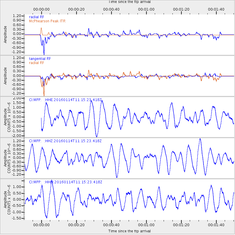
MPP McPhearson Peak - Earthquake Result Viewer
*The percent match for this event was below the threshold and hence no stack was calculated.
| Earthquake location: |
Fiji Islands Region |
| Earthquake latitude/longitude: |
-15.6/-177.2 |
| Earthquake time(UTC): |
2016/01/14 (014) 11:04:18 GMT |
| Earthquake Depth: |
10 km |
| Earthquake Magnitude: |
5.6 mwb |
| Earthquake Catalog/Contributor: |
NEIC PDE/us |
|
| Network: |
CI Caltech Regional Seismic Network |
| Station: |
MPP McPhearson Peak |
| Lat/Lon: |
34.89 N/119.81 W |
| Elevation: |
1739 m |
|
| Distance: |
74.0 deg |
| Az: |
46.039 deg |
| Baz: |
237.523 deg |
| Ray Param: |
$rayparam |
*The percent match for this event was below the threshold and hence was not used in the summary stack. |
|
| Radial Match: |
62.94664 % |
| Radial Bump: |
400 |
| Transverse Match: |
45.555607 % |
| Transverse Bump: |
400 |
| SOD ConfigId: |
7422571 |
| Insert Time: |
2019-04-21 18:29:12.184 +0000 |
| GWidth: |
2.5 |
| Max Bumps: |
400 |
| Tol: |
0.001 |
|
Signal To Noise
| Channel | StoN | STA | LTA |
| CI:MPP: :HHZ:20160114T11:15:23.418Z | 1.1772473 | 5.097883E-7 | 4.330342E-7 |
| CI:MPP: :HHN:20160114T11:15:23.418Z | 2.07732 | 8.590338E-7 | 4.1352982E-7 |
| CI:MPP: :HHE:20160114T11:15:23.418Z | 2.085931 | 1.3579327E-6 | 6.5099596E-7 |
| Arrivals |
| Ps | |
| PpPs | |
| PsPs/PpSs | |


