You are here: Home > Network List > TA - USArray Transportable Network (new EarthScope stations) Stations List
> Station A04D Lummi Island, WA, USA > Earthquake Result Viewer
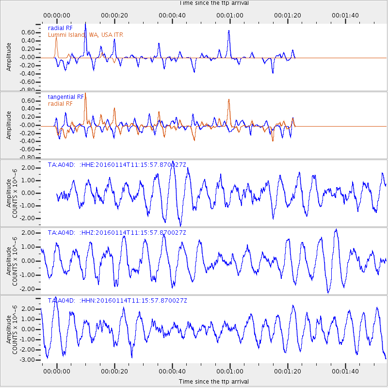
A04D Lummi Island, WA, USA - Earthquake Result Viewer
*The percent match for this event was below the threshold and hence no stack was calculated.
| Earthquake location: |
Fiji Islands Region |
| Earthquake latitude/longitude: |
-15.6/-177.2 |
| Earthquake time(UTC): |
2016/01/14 (014) 11:04:18 GMT |
| Earthquake Depth: |
10 km |
| Earthquake Magnitude: |
5.6 mwb |
| Earthquake Catalog/Contributor: |
NEIC PDE/us |
|
| Network: |
TA USArray Transportable Network (new EarthScope stations) |
| Station: |
A04D Lummi Island, WA, USA |
| Lat/Lon: |
48.72 N/122.71 W |
| Elevation: |
13 m |
|
| Distance: |
80.2 deg |
| Az: |
33.146 deg |
| Baz: |
232.699 deg |
| Ray Param: |
$rayparam |
*The percent match for this event was below the threshold and hence was not used in the summary stack. |
|
| Radial Match: |
83.61116 % |
| Radial Bump: |
372 |
| Transverse Match: |
55.17491 % |
| Transverse Bump: |
400 |
| SOD ConfigId: |
7422571 |
| Insert Time: |
2019-04-21 18:32:18.374 +0000 |
| GWidth: |
2.5 |
| Max Bumps: |
400 |
| Tol: |
0.001 |
|
Signal To Noise
| Channel | StoN | STA | LTA |
| TA:A04D: :HHZ:20160114T11:15:57.870027Z | 1.2516202 | 7.4562166E-7 | 5.957252E-7 |
| TA:A04D: :HHN:20160114T11:15:57.870027Z | 2.1629977 | 1.8746397E-6 | 8.666859E-7 |
| TA:A04D: :HHE:20160114T11:15:57.870027Z | 1.7077788 | 1.0173784E-6 | 5.95732E-7 |
| Arrivals |
| Ps | |
| PpPs | |
| PsPs/PpSs | |


