You are here: Home > Network List > IU - Global Seismograph Network (GSN - IRIS/USGS) Stations List
> Station FURI Mt. Furi, Ethiopia > Earthquake Result Viewer
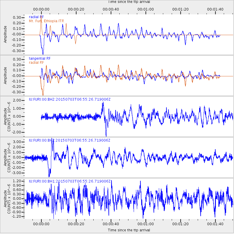
FURI Mt. Furi, Ethiopia - Earthquake Result Viewer
*The percent match for this event was below the threshold and hence no stack was calculated.
| Earthquake location: |
Leyte, Philippines |
| Earthquake latitude/longitude: |
10.2/125.9 |
| Earthquake time(UTC): |
2015/07/03 (184) 06:43:23 GMT |
| Earthquake Depth: |
50 km |
| Earthquake Magnitude: |
6.0 MB |
| Earthquake Catalog/Contributor: |
NEIC PDE/NEIC ALERT |
|
| Network: |
IU Global Seismograph Network (GSN - IRIS/USGS) |
| Station: |
FURI Mt. Furi, Ethiopia |
| Lat/Lon: |
8.90 N/38.68 E |
| Elevation: |
2570 m |
|
| Distance: |
85.8 deg |
| Az: |
278.242 deg |
| Baz: |
80.422 deg |
| Ray Param: |
$rayparam |
*The percent match for this event was below the threshold and hence was not used in the summary stack. |
|
| Radial Match: |
87.955864 % |
| Radial Bump: |
400 |
| Transverse Match: |
76.626564 % |
| Transverse Bump: |
400 |
| SOD ConfigId: |
976571 |
| Insert Time: |
2015-07-17 07:10:36.299 +0000 |
| GWidth: |
2.5 |
| Max Bumps: |
400 |
| Tol: |
0.001 |
|
Signal To Noise
| Channel | StoN | STA | LTA |
| IU:FURI:00:BHZ:20150703T06:55:26.719006Z | 5.125057 | 1.2715756E-6 | 2.4810956E-7 |
| IU:FURI:00:BH1:20150703T06:55:26.719006Z | 1.3060516 | 2.8601642E-7 | 2.189932E-7 |
| IU:FURI:00:BH2:20150703T06:55:26.719006Z | 1.3263948 | 2.975562E-7 | 2.2433457E-7 |
| Arrivals |
| Ps | |
| PpPs | |
| PsPs/PpSs | |


