You are here: Home > Network List > UW - Pacific Northwest Regional Seismic Network Stations List
> Station MRBL Marblemount, WA, USA > Earthquake Result Viewer
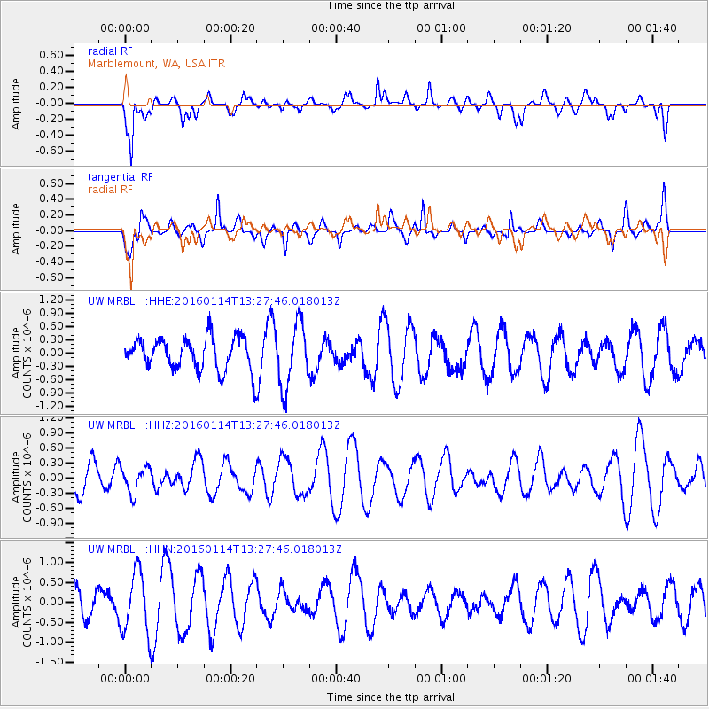
MRBL Marblemount, WA, USA - Earthquake Result Viewer
*The percent match for this event was below the threshold and hence no stack was calculated.
| Earthquake location: |
Mindanao, Philippines |
| Earthquake latitude/longitude: |
9.7/126.4 |
| Earthquake time(UTC): |
2016/01/14 (014) 13:14:49 GMT |
| Earthquake Depth: |
35 km |
| Earthquake Magnitude: |
5.6 MB |
| Earthquake Catalog/Contributor: |
NEIC PDE/NEIC COMCAT |
|
| Network: |
UW Pacific Northwest Regional Seismic Network |
| Station: |
MRBL Marblemount, WA, USA |
| Lat/Lon: |
48.52 N/121.48 W |
| Elevation: |
75 m |
|
| Distance: |
97.0 deg |
| Az: |
38.351 deg |
| Baz: |
293.068 deg |
| Ray Param: |
$rayparam |
*The percent match for this event was below the threshold and hence was not used in the summary stack. |
|
| Radial Match: |
59.41994 % |
| Radial Bump: |
400 |
| Transverse Match: |
59.40104 % |
| Transverse Bump: |
354 |
| SOD ConfigId: |
7422571 |
| Insert Time: |
2019-04-21 18:39:41.548 +0000 |
| GWidth: |
2.5 |
| Max Bumps: |
400 |
| Tol: |
0.001 |
|
Signal To Noise
| Channel | StoN | STA | LTA |
| UW:MRBL: :HHZ:20160114T13:27:46.018013Z | 0.7465848 | 2.586436E-7 | 3.4643568E-7 |
| UW:MRBL: :HHN:20160114T13:27:46.018013Z | 2.1272728 | 7.85505E-7 | 3.6925445E-7 |
| UW:MRBL: :HHE:20160114T13:27:46.018013Z | 2.037852 | 7.141337E-7 | 3.5043453E-7 |
| Arrivals |
| Ps | |
| PpPs | |
| PsPs/PpSs | |


