You are here: Home > Network List > GT - Global Telemetered Seismograph Network (USAF/USGS) Stations List
> Station PLCA Paso Flores, Argentina > Earthquake Result Viewer
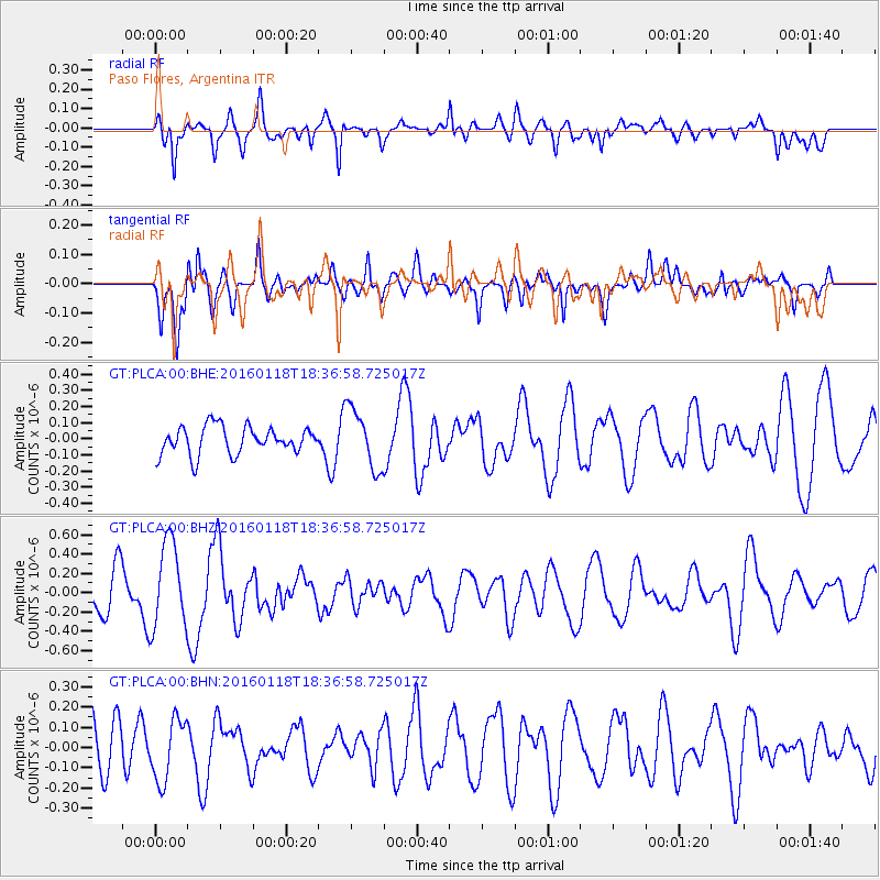
PLCA Paso Flores, Argentina - Earthquake Result Viewer
*The percent match for this event was below the threshold and hence no stack was calculated.
| Earthquake location: |
South Of Fiji Islands |
| Earthquake latitude/longitude: |
-21.5/176.2 |
| Earthquake time(UTC): |
2016/01/18 (018) 18:24:17 GMT |
| Earthquake Depth: |
4.7 km |
| Earthquake Magnitude: |
5.8 MWW, 5.8 MWB, 5.9 MWC |
| Earthquake Catalog/Contributor: |
NEIC PDE/NEIC COMCAT |
|
| Network: |
GT Global Telemetered Seismograph Network (USAF/USGS) |
| Station: |
PLCA Paso Flores, Argentina |
| Lat/Lon: |
40.73 S/70.55 W |
| Elevation: |
1050 m |
|
| Distance: |
92.5 deg |
| Az: |
135.675 deg |
| Baz: |
238.927 deg |
| Ray Param: |
$rayparam |
*The percent match for this event was below the threshold and hence was not used in the summary stack. |
|
| Radial Match: |
65.684586 % |
| Radial Bump: |
400 |
| Transverse Match: |
60.62781 % |
| Transverse Bump: |
400 |
| SOD ConfigId: |
7422571 |
| Insert Time: |
2019-04-21 18:47:19.905 +0000 |
| GWidth: |
2.5 |
| Max Bumps: |
400 |
| Tol: |
0.001 |
|
Signal To Noise
| Channel | StoN | STA | LTA |
| GT:PLCA:00:BHZ:20160118T18:36:58.725017Z | 2.6687756 | 4.453921E-7 | 1.6689005E-7 |
| GT:PLCA:00:BHN:20160118T18:36:58.725017Z | 0.93453443 | 1.5248766E-7 | 1.6316966E-7 |
| GT:PLCA:00:BHE:20160118T18:36:58.725017Z | 2.165596 | 1.8666273E-7 | 8.619463E-8 |
| Arrivals |
| Ps | |
| PpPs | |
| PsPs/PpSs | |


