You are here: Home > Network List > GS - US Geological Survey Networks Stations List
> Station OK031 2598 S. Brethren Rd., Cushing, OK, USA > Earthquake Result Viewer
OK031 2598 S. Brethren Rd., Cushing, OK, USA - Earthquake Result Viewer
| Earthquake location: |
Tonga Islands |
| Earthquake latitude/longitude: |
-20.8/-174.5 |
| Earthquake time(UTC): |
2015/07/06 (187) 12:24:00 GMT |
| Earthquake Depth: |
1.0 km |
| Earthquake Magnitude: |
6.2 MO |
| Earthquake Catalog/Contributor: |
NEIC PDE/NEIC ALERT |
|
| Network: |
GS US Geological Survey Networks |
| Station: |
OK031 2598 S. Brethren Rd., Cushing, OK, USA |
| Lat/Lon: |
35.95 N/96.84 W |
| Elevation: |
290 m |
|
| Distance: |
92.5 deg |
| Az: |
52.495 deg |
| Baz: |
246.188 deg |
| Ray Param: |
0.04144983 |
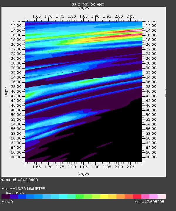
| Estimated Moho Depth: |
13.75 km |
| Estimated Crust Vp/Vs: |
2.10 |
| Assumed Crust Vp: |
6.426 km/s |
| Estimated Crust Vs: |
3.064 km/s |
| Estimated Crust Poisson's Ratio: |
0.35 |
|
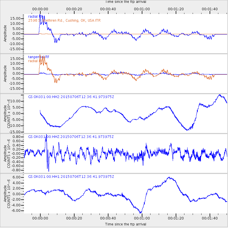
| Radial Match: |
84.19403 % |
| Radial Bump: |
400 |
| Transverse Match: |
62.75372 % |
| Transverse Bump: |
368 |
| SOD ConfigId: |
976571 |
| Insert Time: |
2015-07-20 12:47:49.998 +0000 |
| GWidth: |
2.5 |
| Max Bumps: |
400 |
| Tol: |
0.001 |
|
Signal To Noise
| Channel | StoN | STA | LTA |
| GS:OK031:00:HHZ:20150706T12:36:41.973975Z | 3.2152777 | 3.637806E-7 | 1.1314126E-7 |
| GS:OK031:00:HH1:20150706T12:36:41.973975Z | 1.6863502 | 2.4063663E-6 | 1.4269672E-6 |
| GS:OK031:00:HH2:20150706T12:36:41.973975Z | 1.5799191 | 8.012988E-6 | 5.071771E-6 |
| Arrivals |
| Ps | 2.4 SECOND |
| PpPs | 6.5 SECOND |
| PsPs/PpSs | 8.9 SECOND |


